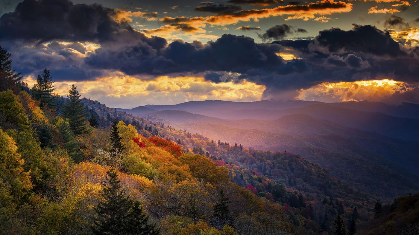
Best Smoky Mountain Historical Sites
Learn about Great Smoky Mountains National Park's most amazing historical sites
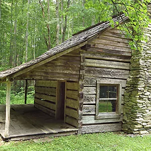
Great Smoky Mountains National Park is home to one of the best collections of log buildings in the eastern United States. There are over 90 preserved or rehabilitated historic structures—including homes, churches, mills, barns and schools. Many of these buildings are on the National Register of Historical Places, and provide wonderful insights to how past communities existed in these rugged mountains. The best locations to see a large amount of historic buildings are: Cades Cove, Oconaluftee, Cataloochee and the Roaring Fork Motor Nature Trail. A map of the historic sites in each area, as well as a picture, can be found here. Below we will go into detail about the most notable buildings, and the best trails in each of these areas.
CADES COVE SITES
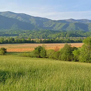 Nowadays, Cades Cove is one of the most popular tourist destinations in the Smokies, but 100 years before the park was established, many families lived in the valley. The first European settlers arrived in the 1820s, and it wasn’t long before they built homes, smokehouses, and barns in the area. By the 1850s, there were approximately 685 people living in the Valley, and thus the need for schools and churches. When the Park Service made their first purchase of land in 1927, there were many people who had to sell their land involuntarily; the last school closed in 1944 and the post office closed in 1947.
In 1945, the National Park Service designated Cades Cove as a historical area and began to maintain and preserve many of it’s buildings. The Cable Mill in Cades Cove is open daily for demonstration spring through fall.
The best way to truly experience the rugged lifestyle of early settlers is to take a hike in their backyard. Cades Cove has many great trails, these are a few of our favorites:
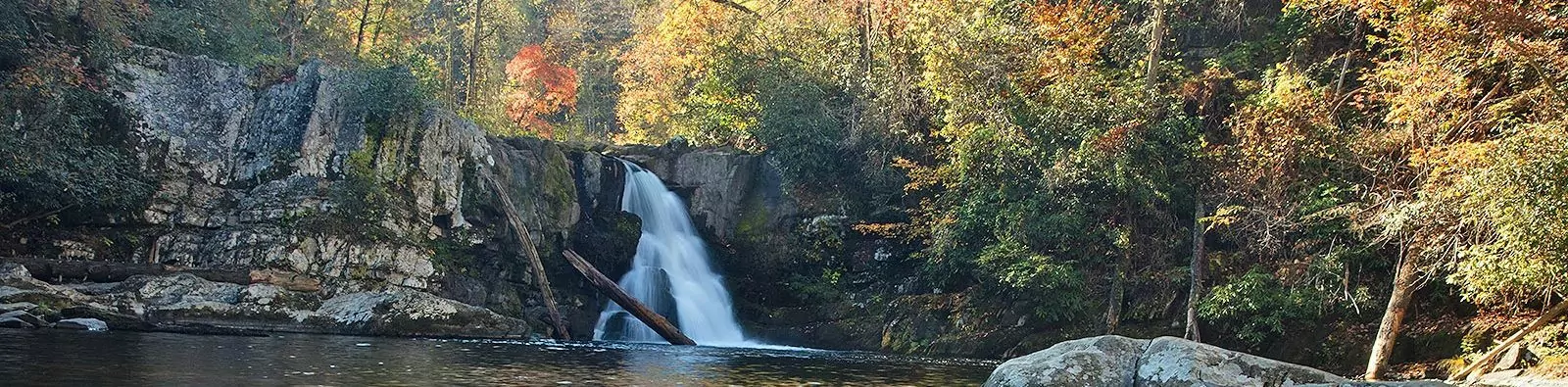
Abrams Falls: Start at the Abrams Falls Trailhead, and hike .5 miles to the Elijah Oliver Place, a homestead built in 1865; in this area is a house, barn, smokehouse and springhouse. The trail continues along the scenic Abrams Creek, to Abrams Falls, 2.6 miles from the trailhead. Abrams Falls is only 20-feet tall, but the sheer amount of water cascading over the side of the cliff makes this waterfall extremely impressive.
Rich Mountain Loop: Start at the trailhead, just before reaching the one-way road of Cades Cove. This 8.5 mile roundtrip hike takes you through a wildflower speckled meadow and past the historic John Oliver cabin. The cabin dates back to the 1820s and is one of the oldest buildings in the Smokies. As you continue past the cabin, you will reach the famous meadow that helped Cades Cove become one of the most popular destinations in the park—exuberant flame azaleas, purple phacelias, rattlesnake hawkweed and yellow ragwort bloom in late spring.
Spence Field: Begin at the Lead Cove Trailhead between Cades Cove and Townsend. Right off the bat, you will pass an old homestead site. At 1.8 miles, you will reach the junction for the Bote Mountain Trail, keep right at the fork and continue uphill until you reach Anthony Creek Trail at 3 miles. Finally, you will get on the Appalachian Trail to reach Spence Field. From Spence Field, you will receive some of the best views of the North Carolina Smokies. This 9.4 mile roundtrip hike is strenuous with an elevation gain of 3100 feet, and requires some route navigating skills.
Rocky Top/Thunderhead: Start at the Anthony Creek Trailhead, at the end of the Cades Cove Picnic Area. This 13.9 mile roundtrip hike is not for the faint of heart—it requires route finding skills and has steep uphill sections, but the pay off is worth it. Thunderhead has three peaks, hiking to Rocky Top is the most accessible route to summit. (And, it was this peak—Rocky Top—that inspired the official state song of Tennessee.) The views from this epic and famous summit are extraordinary. Along the way, you will pass through Spence Field, hike on the Appalachian Trail and through a tunnel of rhododendron—making for one epic journey!
OCONALUFTEE SITES
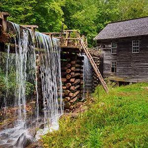
 Oconaluftee, just inside the northern entrance of the park, near Cherokee, NC, is home to the Mountain Farm Museum, a collection of historic buildings—including a house, barn, mill, smokehouse, and applehouse. Many of these buildings were built in the 1900s, and have been gathered from all over the park to be preserved in Oconaluftee for generations to come. Visitors can explore this outdoor museum and imagine how difficult living in this rugged environment would have been. The Mingus Mill is open for demonstration daily, March through October and one weekends in November; you can also purchase cornmeal that was ground using the preserved mill.
Historic and preserved buildings in Oconaluftee are impressive and give you an insight into the communities that once thrived in the Smokies, but the best way to understand just how rugged the terrain was and how harsh their living conditions were is to go on a hike. The best trails near Oconaluftee are:
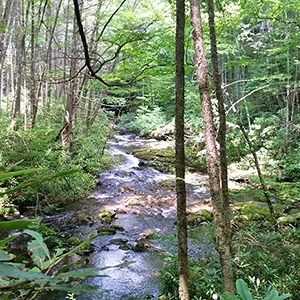
Mingus Creek Trail: Start at the Mingus Creek Trailhead, at the back end of the parking area for Mingus Mill. The mill and trail are named for Jacob Mingus, who moved to the region in the 1790s and was the first European to settle in the now-boundaries of Great Smoky Mountain National Park. Soon after starting you will notice where the mill diverts water from Mingus Creek for it’s operation. And, just over a mile into the trail, you will come to a fork in the path that leads to a family cemetery along Mingus Creek. Vibrant and colorful wildflowers line the trail, and there are two footbridges that cross the creek. As you climb a series of switchbacks, you will encounter five more creek crossings without the benefit of a bridge. This 5.8 mile roundtrip trail is moderate with an elevation gain of 1515 feet.
Smokemont Loop Trail: Start on the Bradley Fork Trail, 3.5 miles north of Oconaluftee, at the Smokemont Campground. The historic Smokemont Baptist Church (also known as the Luftee Baptist Church—the National Park Service has two signs with two different names) is near the start of the trail. This loop trail takes you along the Bradley Fork Creek, passing an abundance of wildflowers in the early spring. Follow signs as you hike, as the loop connects multiple trails. As you reach the top of the climb, you will have views of Newfound Gap and the North Carolina Smokies. This trail is moderate with an elevation gain of 1441 feet.
Newton Bald Trail: Begin on the Newton Bald Trail in Smokemont, this strenuous trail takes you almost straight uphill, gaining 2900 feet in 4.6 miles. (A bald is a treeless meadow on a ridgeline, typically found in the Appalachian Mountain region. Legend has it that these areas were prime hunting grounds, but history can’t quite determine if it was the Cherokee that cleared the land, or European settlers.) In route to the bald, you will hike through a lush hemlock forest that tunnels the trail. Once you reach Newton Bald, you are rewarded with expansive views of the North Carolina side of the Smokies—the rolling and forests ridgelines are seemingly endless.
Enjoy the history of Oconaluftee and other Great Smoky Mountains highlights on a guided day hike! Smoky Mountains in a Day Tour takes you to famous waterfalls, incredible high country views, and through Oconaluftee on a full day adventure. Or, if you want to experience more of the park than just one day, consider joining a 3-day Smoky Mountains Hiking Experience guided tour, which takes you to impressive waterfalls and famous peaks, as well as Oconaluftee and Cades Cove.
EXPERT-LED APPALACHIAN BACKPACKING TRIPS

CATALOOCHEE SITES
 Cataloochee is located on the east side of the park, and the surrounding mountains, standing tall at 6000 feet, are some of the most rugged terrain in southeastern United States. In it’s heyday—the early 1900s—the community of Cataloochee was home to 1,200 residents. Most had an income supported by farming, but as the area became more popular, they began to house tourists who wanted to fish and relax in the mountains. Nowadays, this area hosts a collection of preserved buildings, including a school, churches, and houses. The structures are the best representation in the park of 19th and 20th century frame buildings, and have been beautifully preserved by the park system.
There are many things to do in Cataloochee, including wildlife viewing, fishing and hiking. Elk were reintroduced in the area in 2001, and are thriving; making this a great place to watch the elk rut in the fall. Other wildlife you may see include wild turkeys, deer and black bears. In addition, Cataloochee Creek is known for it’s abundant trout population. A fishing license is required from either North Carolina, or Tennessee. Lastly, hiking is a very popular activity to do in Cataloochee. The best hiking trails in the area include:
Boogerman Trail: Start on the Caldwell Fork Trail, just past the Cataloochee campground. The Boogerman trail junction is just over 8/10 of a mile, and once you are on the trail, you will be hiking through a rich old-growth forest; some of the oldest and tallest trees in Cataloochee are along the Boogerman Trail. At 2.3 miles, you will pass the historic Palmer homestead, and at 4 miles, you will reach the remnants of the Carson Messer homestead. You will find the junction for the Caldwell Fork Trail again at 4.7, and take a right here to loop back to the trailhead. This 7.4 mile loop trail is moderate with an elevation gain of 1040 feet.
Little Cataloochee Trail: Start on the Pretty Hollow Trail, located across from the Cataloochee Horse Camp. The junction for Little Cataloochee Trail is at .8 miles, and will soon begin an uphill climb—rising over 900 feet in 2 miles. The first historic homestead along the trail hosts a blacksmith and woodworking shop, as well as a sawmill. After this, you will reach the Cook Cabin, and the Little Cataloochee Baptist Church and it’s cemetery, built in 1889. Lastly, you will reach the Hannah Cabin, which was home to the first settler in Cataloochee Valley. This 6.1 mile trail is moderate with an elevation gain of 1100 feet.
Mount Sterling: Start on the Mount Sterling Trail at Mount Sterling Gap, 7 miles north of Cataloochee campground. This strenuous trail takes you on a climb of 2000 feet in less than three miles. Wildflowers cover the ground in early spring, and you will pass through an old-growth forest in route to the summit. On a series of switchbacks, you will be given occasional views of Cataloochee and the surrounding area. When you reach the Mount Sterling summit at 5842 feet, you have views of Mount Guyot, Luftee Knob and Balsam Mountain. A shaky, 60-foot fire tower stands at the top, and although the Park Service now uses it as a radio repeater, you can climb the many steps to the outlook for an incredible, panoramic view.
Rough Fork Trail: Begin on the Rough Fork Trail, located at the end of the road in Cataloochee Valley. A one-mile hike to the Woody House, which was built in 1880 by Steve Woody, takes you through a tunnel of trees and on many footbridges over the Cataloochee Creek. Originally, as one room cabin, it was expanded over time as lumber became more available. The house is open, so you can go in and explore at your own risk. This 2 mile roundtrip hike is easy with an elevation gain of 120 feet.
ROARING FORK MOTOR NATURE TRAIL SITES
 Roaring Fork Motor Nature Trail is located at the north of Great Smoky Mountains National Park, just inside the boundaries from Gatlinburg, TN. The 5.5 mile road is a great side trip to your Smoky Mountain adventure. Along the road, you will be going through old-growth forest, with rushing streams, and a collection of well-preserved historic buildings, including log cabin homes, barns, mills and granaries. (Note: Roaring Fork Motor Nature Trail is closed from December to mid-March.) The best hikes along the Roaring Fork Motor Nature Trail are:
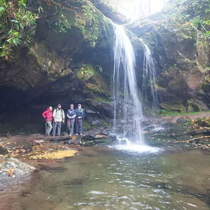
Grotto Falls: Begin at the Trillium Gap Trailhead; you will be on this trail for a majority of the hike to Grotto Falls. Choosing to hike Trillium Gap Trail in the spring, you will see a significant amount of wildflowers speckling the side of the trail. At 1.3 miles, you will reach Grotto Falls, which is impressive because it is the only waterfall in the park that you can stand behind and feel the power of it’s mist, providing great respite for a hot summer day (salamanders think so too, and can be found lounging on the cool, wet rocks!) This out-and-back hike is easy with an elevation gain of 585 feet.
Brushy Mountain: To get to Brushy Mountain, you will continue past Grotto Falls (as described above). At 3 miles, you will reach Trillium Gap, there is a fork in the road here; taking a left will lead you to Brushy Mountain, and taking a right will lead to Mount LeConte. This last push to the summit is through a tunnel of rhododendrons and other vibrant wildflowers. At the summit, you get a fantastic vantage point to the eastern Smokies—looking at Charlies Bunion, Mount Sequoyah, Mount Chapman and Mount LeConte. This 6.8 mile roundtrip hike is strenuous with an elevation gain of 1745 feet.
Mount LeConte: Begin on the Trillium Gap Trail (as described above), hike past Grotto Falls and to the junction of the Brushy Mountain Trail. Take a right at the fork and continue for 3.6 miles until the trail dead ends into the Rainbow Falls Trail. Mount LeConte Lodge will be just past the junction, and to reach the summit of Mount LeConte, take a left and continue for .3 miles. The peak is the third tallest in the Smoky Mountains, and rewards you with spectacular views of the Charlies Bunion and the northern Smokies’ rolling ridgelines. This 13.9 mile roundtrip hike is strenuous with an elevation gain of 3401 feet.
Rainbow Falls: Start on the Rainbow Falls Trail, located just past the Noah “Bud” Ogle homestead. The first section of the trail is a steady uphill on a large boulder field, and there are two footbridges that cross over LeConte Creek. At 2.7 miles, you will reach Rainbow Falls, which is the tallest single drop waterfall in the park. It got the name for a rainbow that is projected in it’s mist on a sunny day. This 5.4 mile roundtrip hike is moderate with an elevation gain of 1500 feet.
JOIN A GUIDED HIKING ADVENTURE
 Great Smoky Mountains National Park is a rich, pristine wilderness with abundant wildlife, amazing views and unforgettable opportunities for hiking vacations. Wildland Trekking offers a variety of ways to enjoy the Smoky Mountains, including backpacking trips, portered treks, inn-based tours and day hikes.
Guided Smoky Mountain treks are all-inclusive meaning the following is included: local round trip transportation from Asheville; wonderful meals; top-of-the-line equipment; risk management systems; professional hiking/wilderness guides and more.
SMOKIES ADVENTURE TOURS
- GUIDED BACKPACKING TRIPS: these adventures are opportunities to explore the deep wilderness and extraordinary beauty of the Smokies.
- PORTERED HIKES: hike and camp far in the backcountry of the Appalachian Mountains with the convenience of light day packs and expert guides.
- INN-BASED HIKING TOURS: discover the magic of the Smoky Mountains on amazing daily hikes and enjoy wonderful Appalachian accommodations at night.
- DAY HIKE TOURS: make the most of your time in Great Smoky Mountains National Park with our expert guides and all-inclusive tours!
- ASHEVILLE AREA HIKING ADVENTURES: explore the stunning Blue Ridge Mountains around Asheville on backpacking, portered, and inn-based tours!
Related Pages