
Tanner Trail
General Description
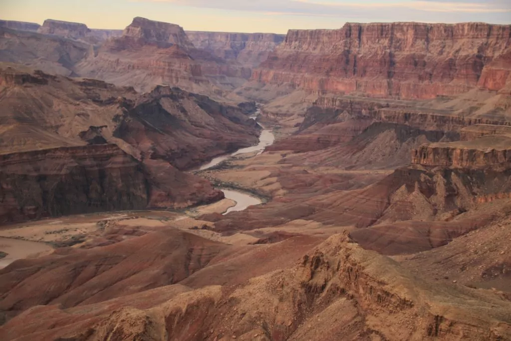
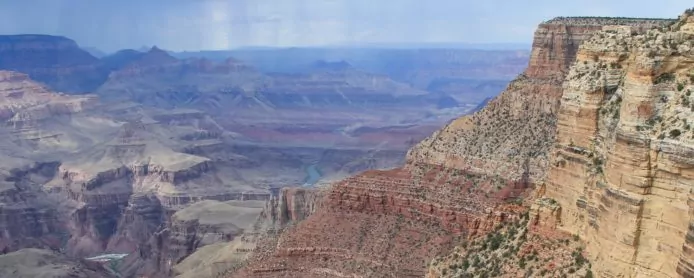
Tanner Trail is located 23 miles east of Grand Canyon Village. From the trail you can see the incredible Unkar Rapid, and the tilted layers of rock called the Grand Canyon Supergroup. It is not frequently maintained by National Park Service, and there are sections of rock slides where route finding skills are essential. The trail is a steep descent into one of the widest and most colorful areas of the park. From the trailhead, it is about 9 miles to the Colorado River. There are also two primitive trails that intersect with Tanner Trail, the Escalante running west, and the Beamer running east. The Tanner Trail is perfect for getting you deep into the canyon on great and foreign trails. With wide-open views and layers of exposed rock unseen many other places, the views from Tanner Trail look like a photograph on a postcard from long ago. The views are some of the best in all of Grand Canyon National Park.
Explore Grand Canyon with Experts
Getting to the Tanner Trailhead
The Tanner Trailhead is located at Lipan Point off Desert View Drive. From South Entrance Road, Lipan Point is 23 miles east. And from the Desert View entrance station, it is 6 miles. There is a small parking lot at the point where you can leave your car. The trailhead starts just east of the parking area, there is a large interpretive sign marking it.
History of the Tanner Trail
The route was originally used by the Anasazi and Hopi tribes to access the Colorado River. These days, most historians believe that Tanner Canyon is the spot where García López de Cárdenas stood in 1540, becoming the first European to see the Grand Canyon. Later, it was named Tanner Trail after the prospector Seth Tanner, who improved the trail so he could have better access to his mining claims in the canyon.
The Grand Canyon Supergroup is visible from the Tanner Trail, and is every geologists’ dream. In much of the Grand Canyon, the Supergroup is unable to be seen, simply because it is not there, it has been eroded away. So, being able to view the Supergroup from Tanner Trail and other points on east Desert View Drive is pretty extraordinary. It is also the last trace of the “Great Unconformity”– the millions of years of rock history that is missing between the Tapeats sandstone and the Vishnu Schist.
2 Best Day Hikes on the Tanner Trail
Day hiking on the Tanner Trail is world-class because of it’s wide-open views. Hikers are able to see for miles and miles, and see some of the most spectacular rock layers in the canyon, in a short amount of time. As always, make sure you bring plenty of water on these trips, as the only water is at the Colorado River.
Below are the primary options for day hiking the Tanner Trail:
| Destination | Miles (roundtrip) | Elev | Difficulty | Style | |
| Tanner Canyon Saddle | 3.8 mi | 1,740 ft | Moderate | Out and Back | |
| Palisades of the Desert Overlook | 7 mi | 1,700 ft | Moderate-Strenuous | Out and Back |
1. Tanner Canyon Saddle
The first part of Tanner Trail is narrow and steep, and requires very sure footing. It slopes down through the Toroweap and once you reach the Coconino, there are many sections of the trail that are taken over by previous rock slides. The trail descends steeply all the way down to the saddle. This is a great stop to take a break and look out into the beauty of the canyon. When ready to head back to the rim, simply turn and hike out the same way you came down.
2. Palisades of the Desert Overlook
This overlook is past the Seventyfive Mile Creek – Tanner Canyon saddle, as described above. Some say that the only civilized hiking on the entire trail belongs to this section of the Tanner Trail. Nearing the bottom of the Supai, you will traverse the base of Cardenas and Escalante Buttes. As you reach the top of the Redwall, Tanner Trail will continue to your right, descending a series of switchbacks. Instead of following the trail down the switchbacks, continue straight for about a hundred feet. Here, is a great picnic spot with views of the widest part of the Grand Canyon. Take in these views with pride, not many people get to experience the Grand Canyon like this. When ready to return the the south rim, follow the Tanner Trail up the same way you came down.
Maximize Your Visit to Grand Canyon National Park on a Hiking Tour
Guided day hike tours and multi-day packages allow visitors the opportunity to make the most of their time in Grand Canyon National Park and to do it hassle-free. Guided tours include gear (backpack, trekking poles, crampons in winter), meals, accommodations on multi-day tours, local transportation, and a professional Arizona hiking guide. Through their knowledge, stories, and personal passion, guides can bring a place to life in a way that’s much more difficult to do on your own. Read more about Grand Canyon Hiking Tours.
Award Winning USA Hiking Vacations
3 Tanner Backpacking Trips
The Tanner Trail is a premier backpacking trail because of it’s panoramic views right from the start. Also, because you have access to other incredible trails to the east and west, the Escalante Route and the Beamer Trail.
| Route | Miles (roundtrip) | Difficulty | Campgrounds | |
| Tanner Beach | 18 mi | Strenuous | Tanner Use Area (BB9) | |
| Escalante Route | 34.8 mi | Strenuous | Tanner Use Area (BB9) Seventyfive Mile Creek (BC9) Red Canyon Use Area (BD9) |
|
| Beamer Trail to Little Colorado River |
37 mi | Strenuous | Cardenas Use Area (BC9) Palisades Use Area (BA9) Tanner Use Area (BB9) |
1. Tanner Beach (2 days)
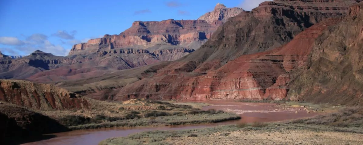
Getting down the the Colorado River via the Tanner Trail is no easy feat. Rock slides have taken out many sections of trail at the top, and many parts are narrow and steep. The National Park Service even goes as far as to say that the Redwall is “nasty”, as it is steep and loose and unforgiving. You will reach a small saddle on top of the Tapeats Sandstone, and eventually get to the Dox Sandstone, a layer in the Supergroup unseen many other places. However, the trail chokes down to about a feet wide and traverses along a slope. Continue descending boldly as the trail drops to the shoreline of the Colorado River. This is Use Area BB9 and allows backpackers to camp anywhere in the area, although using pre-established sites is highly suggested. Wake early the next morning, filter water from the Colorado, and start your steep ascent back to the rim.
2. Escalante Route (4 days)
This trip is done using a shuttle system, leaving one car at the trailhead of the Tanner Trail and one at the New Hance Trail. It can be done Tanner to New Hance, or vice versa. The Escalante route is a tough route and not for beginners.
The Escalante Route has steep exposure, with almost no shade whatsoever. But, it is one of the most beautiful and rewarding hikes in the entire park. Backpackers will hike down to Tanner Beach, as described above, and may want to camp in Use Area BB9 after the grueling 9 mile descent. Wake up the second morning ready for the adventure of your lifetime. On the beach of the river, look for a rock-lined path that leads downriver. This will take you up on a bench, where you will traverse across the Supergroup to a dry Cardenas Creek. From here, the trail is steep and exposed, and will take you on a climb, winding in and out. Use Area BC9 is all along the Escalante Route, so make use of an established site if you are in need of rest. The route continues over ridges and and through dried up creek beds; dropping you down to river level, only to have you hiking up cliffs again. You will eventually get to Hance Rapid and the mouth of Red Canyon. At this point you can either spend the night at the beach, or continue up the New Hance Trail for a campsite. On the morning of the fourth day, wake early and start your hike out of the middle of the earth, to the south rim.
3. Beamer Trail to Little Colorado River (4 days)
The Beamer Trail begins near the beach of Tanner Rapid, it is not marked by a sign, but rather by rock cairn. The trail is hard to follow– it will have you going up, down, over cliffs, on the side of cliffs; extreme exposure is very present on this trail. You will be following rock cairns the entire way, if you are even unsure of where the trail is, pause and take a look around, you should be able to see one of the many rock stacks. Due to lack of water and shade, it is a particularly difficult trip, since the only water source is the Colorado River, which can be very sediment-laced and difficult to filter. It is not recommended to drink out of the Little Colorado, due to uranium contamination.
If you are still up for the challenge, you are rewarded with amazing views of the Colorado River the entire way, big views of the North Rim, and of course, the sacred site of the Little Colorado Confluence. Camping is not allowed at the point of the confluence, so you will be camping about a half mile shy of the confluence at a small beach. This trip is best done spending one night at Tanner Beach, one night at the spot right before the confluence, and then one last night at Tanner before making your ascent back to the rim. In order to see the turquoise color of the Little Colorado mixing with the Colorado River, it is best to check with the backcountry office for current conditions, because it is not always running this color, due to storms and water runoff.
Join a Guided Grand Canyon Backpacking Trip
Joining a Grand Canyon backpacking tour is a worry-free, adventurous way to experience Grand Canyon. With your gear, meals, local transportation, permits, and fees taken care of for you, you can travel light and focus 100% on enjoying the hiking experience, while the guide company takes care of everything else. Also, by going with local experts you’ll enjoy a greater level of safety and gain a much better understanding of the history and ecology of this remarkable region. Read more about a guided Grand Canyon backpacking trips.
All-inclusive Grand Canyon Backpacking Adventures
When to Hike and Seasonal Considerations
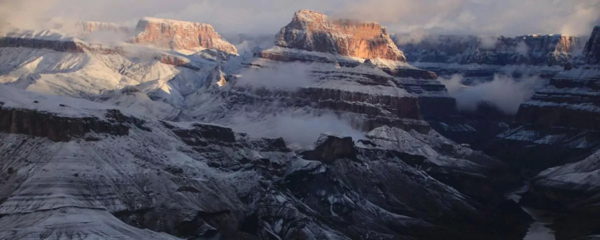
The Grand Canyon is known for getting hot, and the Tanner Trail is specifically noted for being unusually hot. This wide-open area of the canyon means that the hot summer sun rises early and sets late. There is also no water along the trail, and therefore no vegetation, and not much shade. Make sure you bring sunscreen and long-sleeve layers for protection against the sun. Since the only water source is the Colorado River, make sure you bring plenty with you, and consider caching water for the way up. Always check the weather of the Grand Canyon before starting any trip.
Necessary Permits
Day Hike Permits
Day hikes do no require a permit in Grand Canyon National Park.
Backpacking Permits
If you are planning a backcountry trip, you will need a permit. In the busy season, many trails’ permits are through a lottery system, and advanced planning is essential. For more information on Grand Canyon’s permit system, click here.
Suggested Packing List
Day Hike Packing List
- 3-6 liters of water (more in summer)
- Salty, calorie-rich snacks
- lunch
- backpack
- trekking poles
- crampons (in winter)
- wide-brimmed hat
- sunscreen, sunglasses
- non-cotton t-shirt
- rain jacket
- warm non-cotton layer
- 1st-aid kit
Backpacking Packing List
- all items listed for day hikes PLUS
- multi-day backpack
- 3-season tent
- map
- headlamp
- sleeping bag
- sleeping pad
- backpacking stove and fuel
- backpacking meals
- 3 pairs wool socks
- extra t-shirts
- water filter or water filter tablets
- large dromedary to carry extra water
Please Respect Our National Parks – Leave No Trace
We strongly recommend abiding by all Leave No Trace ethics guidelines and practices so that our national parks and public lands are preserved for the enjoyment of future generations and for the people and animals who call these places home. Simple things like packing out your trash, obeying national park rules, and respecting the peace and quiet of our national park trails is a great start. If you’re going on a backpacking trip, you can read about more about the 7 Leave No Trace Principles.

