
Top 10 Hiking Trails in the USA

The United States has some of the best hiking trails in the world, with diverse landscapes ranging from unearthly desert environments, to rugged alpine passes and ridgelines, to meandering coastlines. These top ten trails are a great example of the wide variety of hiking in the USA; each of these trails offers something unique to both satisfy your senses and fuel your excitement. Get out and explore these trails, knowing they barely scratch the surface of the wonder that exists deep in the canyons, high in the mountains, and everywhere in between.
Award Winning USA Hiking Vacations
| Trip | Difficulty | Days | Miles |
| South Kaibab Trail, Grand Canyon National Park, AZ | Strenuous | 1 | 3 – 6 |
| Ocean Trail, Acadia National Park, Maine | Easy | 1 | 4.4 |
| Mohonk Labyrinth and Lemon Squeeze, New Paltz, NY | Moderate | 1 | 5.5 |
| Vesper Peak, North Cascades, WA | Strenuous | 1 | 8.0 |
| Clouds Rest, Yosemite National Park, CA | Moderate | 1 | 14.5 |
| Monarch Lake to Crater Lake, Indian Peaks Wilderness, CO | Moderate | 1-2 | 14.9 |
| Highline Trail, Glacier National Park, MT | Strenuous | 1 | 14.9 |
| Paria Canyon & Buckskin Gulch, Vermillion Cliffs Wilderness Area, UT | Moderate | 3 – 5 | 14 – 38 |
| Teton Crest Trail, Grand Teton National Park, WY | Strenuous | 3-5 | 40 |
| Wonderland Trail, Mount Rainier National Park, WA | Strenuous | 9-13 | 93 |
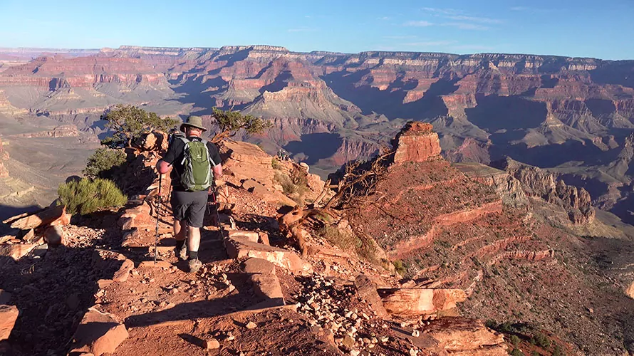
1. South Kaibab Trail, Grand Canyon National Park, Arizona
Trail Overview
Hiking the South Kaibab Trail is one of the best ways to experience the Grand Canyon. This trail descends a series of steep, exposed switchbacks, allowing you to grasp the magnitude of the canyon as you stare into its depths. Incredible views greet you right from the canyon rim, but they continue to evolve and expand with every step down the trail. This trail is the most direct route to the Colorado River, and you’ll feel it as you steeply follow the dramatic ridgeline into the canyon. This magnificent hike enables you to take in the glory of the Grand Canyon at your skill level, offering multiple turn-around points to satisfy all day-hikers.
Trail Details
You begin your hike at Yaki Point on the canyon rim. Here, it is crucial to fill up water so that you have all you need for the duration of your hike. The National Park Service recommends carrying at least four liters of water in hot weather. There is no water available along the South Kaibab Trail.
Hit the trail as layers of sedimentary rock unfold before you — a visible geological record of nearly two billion years. You weave through Kaibab Limestone as you begin your descent. This rock, once settled on the seafloor, was uplifted through geological processes and now forms part of the canyon rim. As you continue your descent, you traverse through a new layer of rock — Coconino Sandstone — obtaining your first panoramic views of the canyon at the aptly named Ooh Aah Point. The trail continues downhill from here. Mules are commonly encountered along this path, as they shuttle supplies back and forth from Phantom Ranch at the bottom of the canyon. Be sure to step to the side when they are passing – they have the right of way.
There are two main turn-around points for day hikers: Cedar Ridge and Skeleton Point. Cedar Ridge is a 3 mi roundtrip hike, and Skeleton Point is 6 miles in total. On a hot summer day, Cedar Ridge makes a great turnaround point. While the entire trail is notorious for lacking shade, Cedar Ridge offers a small bit of respite to recover before you begin your hike out. If you’re hiking in cooler seasons, Skeleton Point is a rewarding destination. Sitting 1.5 miles further down the trail, Skeleton Point gives you your first glimpse of the Colorado River, still almost 3000 feet below you.
Remember, every step you take into the canyon you have to take back out. The return hike can be significantly more taxing on the lungs and body than the descent, so hikers are often fooled into covering more miles down than they want to climb out. Err on the side of caution and turn around before you get tired.
Parking
Due to the popularity of the area, parking is not permitted at the trailhead. Two shuttles — the Kaibab/Rim bus route and the Hiker’s Express — provide access to the trail. The Hiker’s Express is a morning shuttle and is the best bet for those looking to hit the trail early.
Permits, Fees, and Reservations
An entrance fee* of $35 per vehicle, or $20 per individual, is required to enter the National Park.
*The America the Beautiful National Park Pass would cover this entrance fee.
When to Hike
This hike is accessible year-round but requires special considerations in certain seasons. Spring and fall are lovely times of year to hike the South Kaibab Trail, as summer temperatures have dropped but winter conditions have not yet set in.
From May to September, heat precautions should be taken and hikers should get an early start and set a reasonable turnaround point, like Cedar Ridge. Avoid hiking at mid-day between 10 AM and 3 PM.
In winter months, ice could be encountered during the initial steep switchbacks, so microspikes are advised. Temperature changes from canyon rim to canyon bottom can be extreme, so hikers should be prepared for differing weather conditions.
Hike the South Kaibab Trail with A Guide
Guided South Kaibab Trail day hikes are available and are a stress-free, exciting way to do this hike. The tour company handles gear, snacks, and lunch, and provides a professional, knowledgable guide so you can focus 100% on enjoying your adventure. Read more…
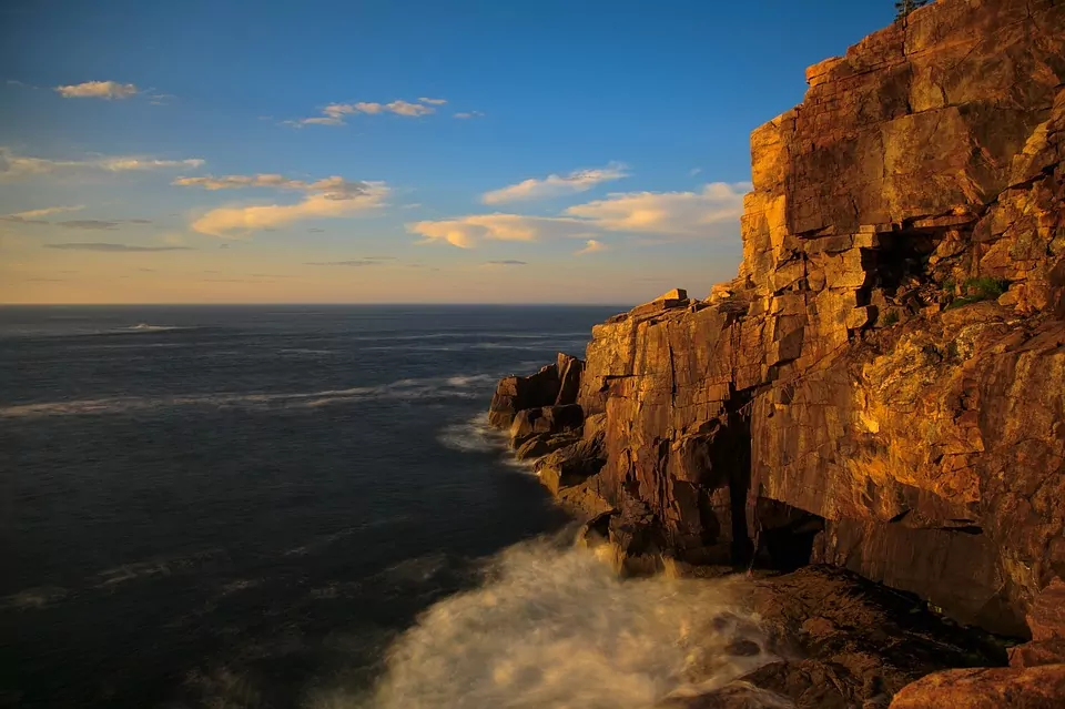
2. Ocean Trail, Acadia National Park, Maine
Trip Overview
This family-friendly beach stroll is great for hikers of any level. The Ocean Trail provides inspiring views of the rocky Northeastern coastline, allowing you to experience the roaring of the water as it tumbles through Thunder Head. This cave is one of the iconic rock features along the hiking trail. If you’re looking to add mileage or adventure, this trail serves as a jumping-off point for many other trails in Acadia National Park. You will have the opportunity to head up to Gorham Mountain or the Beehive to create a one-of-a-kind hiking loop.
Trip Details
This trail starts at the Sand Beach parking lot and travels along the coastline, paralleling the Park Loop Road, to Otter Point. There is minimal elevation gain with numerous ocean vistas and access points to the rocky outcroppings at the water’s edge. Due to its easy difficulty-level, this trail gets crowded mid-day. Avoid the tour buses and begin hiking at sunrise or sunset, as the golden rays cast a glow on the blocky, orange cliffs of Otter Point.
Dogs are permitted on leash on this trail.
Permits, Fees, and Reservations
An entrance fee of $30 per vehicle, or $15 per individual, is required to enter Acadia National Park.
When to Hike
This trail is accessible year-round. In the winter, the granite path can get incredibly icy so plan ahead and make sure to bring trekking poles.
Explore Your World with Expert Guides
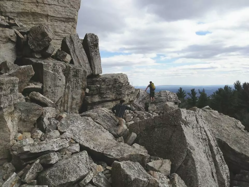
3. Mohonk Labyrinth and Lemon Squeeze, New Paltz, New York
Trip Overview
This trail in the Hudson Valley is more of a scramble than a hike, heightening your sense of adventure as you place your feet carefully and navigate through fields of rocks. The ‘Labyrinth’ is aptly named – you’ll weave under, over, and between boulders, looking for red blazes to guide you. You’ll ascend ladders and squeeze through crevices as you make your way to Sky Top Lookout, high above the valley floor.
Trip Details
This trail starts at the Mohonk Mountain House, a historic resort with miles of hiking trails. You’ll follow trails through the grounds, passing gardens and gazebos for a couple of miles before arriving at the Labyrinth – a rocky scramble that twists and turns through a maze of boulders.
The ‘Lemon Squeeze,’ the final obstacle, will test your claustrophobia as you climb a ladder suspended between two giant rocks. Once you emerge from the Lemon Squeeze, you will find yourself atop a cliff, at the Sky Top Lookout, where you can take in the views of the Hudson Valley spreading below you.
Permits, Fees, and Reservations
This trail is located at the Mohonk Mountain House on private property; there is a $22 entrance fee per person to access the grounds. Day-pass prices increase on weekends and holidays. Hiking passes cannot be purchased in advance.
When to Hike
This trail is closed during the winter and can only be accessed seasonally as determined by the Mohonk Mountain House. This scramble gets slippery when wet, so should be avoided during rainy weather.
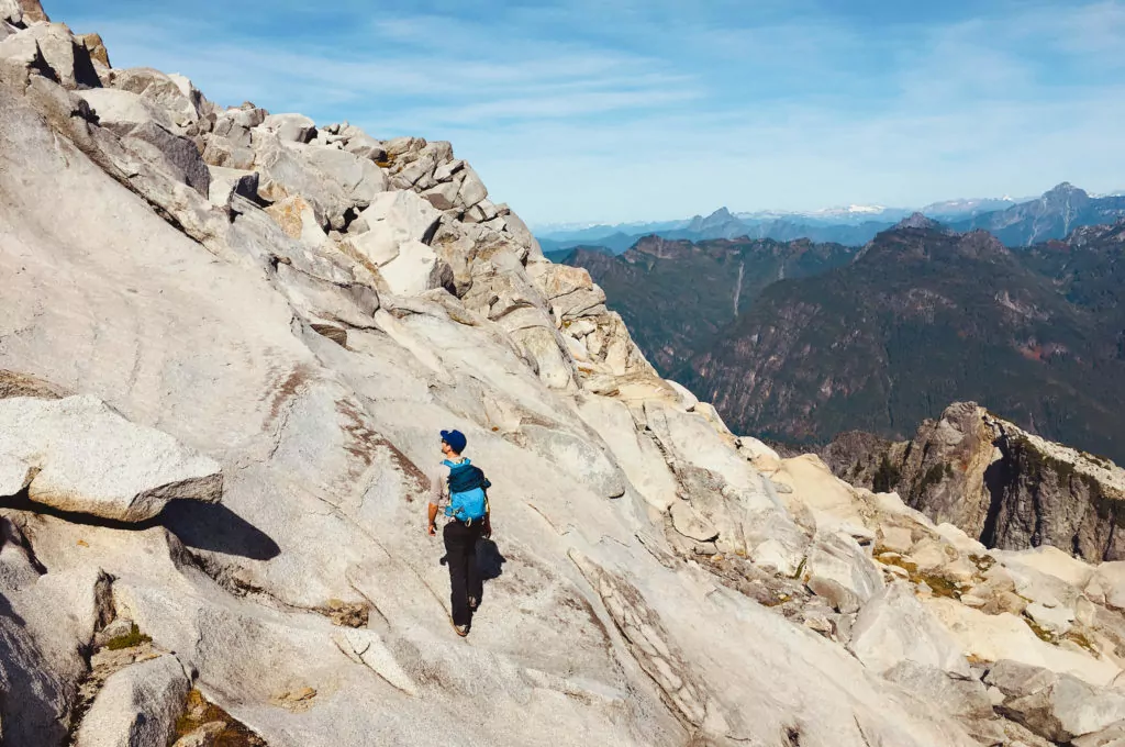
4. Vesper Peak, North Cascades, Washington
Trail Overview
Vesper Peak is a gem in the North Cascades; a choose-your-own-adventure route with glorious hiking on giant slabs of white granite. It sits in the heart of the Cascade Range, among a sea of rocky ridgelines and deep blue alpine lakes. 360-degree views greet you at the summit, leaving you surrounded by a rainbow of color. The emerald green of the forests, the azure of Copper Lake in the valley far below, the icy-blue of Lake Elan, and the iron red of Big Four Mountain in the distance make for an unforgettable view.
This hike isn’t suited for beginners; the route up to Vesper Peak is a tough one, with over 4000 feet of elevation gain in 4 miles. However, this trail requires minimal route-finding and is relatively low exposure, making it an excellent introduction for experienced hikers to take on more challenging terrain. If the final trek up to the summit of Vesper Peak seems too tricky, Lake Elan,which sits in the basin below the peak, is a worthwhile destination. Here, you can soak in the views before the long descent to the trailhead.
Trail Details
The hike starts in a dense, mossy forest and takes you over a stream crossing. From here, it quickly opens up into a beautiful basin with towering peaks on either side, leaving you wondering how you’ll ever climb up and over the near-vertical walls. You’ll cross long talus fields, listening to the squeaks of pika as they skitter in and out of the rocks. As you hike, the towering walls transform in front of you, revealing a gully that takes you up to Headlee Pass. Once at Headlee Pass, Vesper Peak appears before you, towering high in the distance.
After crossing Headlee Pass, the route narrows and you should watch for cairns, or rock piles, to guide you. (Cairns are used as trail markers, and new ones should not be created by hikers for fun. False cairns could lead other hikers into dangerous terrain. Also, alpine species like pika rely on the spaces between rocks as habitat, so any relocation could potentially disturb an animal’s home!)
Once you get onto the granite slab at the flanks of Vesper Peak, this hike becomes an off-trail scramble. The occasional use of hands may be required, depending on which path you take to the summit. The rock is grippy, the angle is low, and the route options are plentiful, so play around until you find a path that feels comfortable to you!
Permits, Fees, and Reservations
An Interagency Pass or Northwest Forest Pass is required to park at the trailhead. Make sure to sign the trail register before setting out on your hike.
When to Hike
Snow lingers here late into the season and can significantly increase the difficulty of this trail. Wait until late summer to attempt this hike, unless you have experience with snow travel and bring the proper gear.
This trail will be mostly snow-free from mid-July through September. Road and trail conditions can vary depending on the year.
Explore North Cascades on a Guided Trip!
Guided North Cascade backpacking trips are available and are a stress-free, exciting way to get into the wilderness. The tour company handles permits, gear, transportation, meals, and provides a professional guide so you can focus 100% on enjoying your adventure. Read more about backpacking with Wildland…
5. Clouds Rest, Yosemite National Park, California
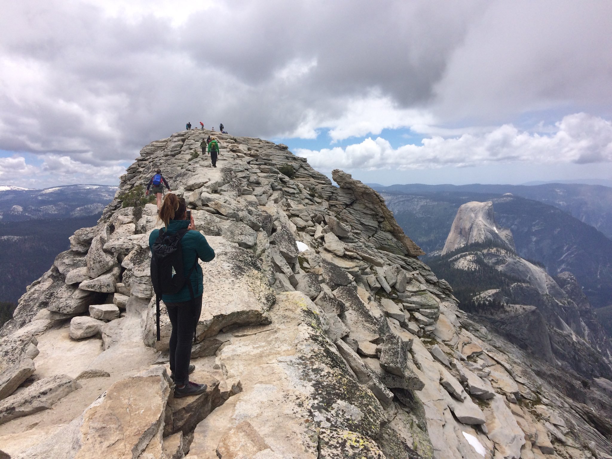
Trip Overview
Clouds Rest is an awe-inspiring alternative to Half Dome, without the crowds and pesky permit system. As you gaze down at Half Dome and the entire Yosemite Valley, you might catch a glimpse of hikers heading up the cables on Half Dome’s rounded back. Although there aren’t cables on this hike, Clouds Rest has its fair share of adventure. You traverse an exhilarating “sidewalk” with significant exposure on either side. 3000-foot drop-offs into the valley below greet you as you clamber along granite rocks on this narrow summit. For those without a strong fear of heights, this is one of the best hikes Yosemite has to offer.
Trip Details
The Clouds Rest Trail starts at high-elevation along Tioga Pass at the Sunrise Lakes Trailhead. Within minutes of leaving the trailhead, you encounter the Tenaya Lake outlet. Early in the season, you will have to ford this river, but later in the season, there is a set of rocks to provide a relatively dry crossing. After a deceivingly flat start to the hike, you climb a series of steep switchbacks that lead you to a fork with the Sunrise Lakes trail. Descend slightly and meander through rolling meadows and sub-alpine forest as you approach Clouds Rest. A final steep ascent leads you to the Clouds Rest foot trail where you will take in 360-degree views of most of the park.
Visit Clouds Rest during dry weather – rain can make the granite slick, and a fall from either side of the crest could be fatal.
Permits, Fees, and Reservations
An entrance fee of $35 per vehicle, or $20 per individual, is required to enter Yosemite National Park.
When to Hike
Late June through September are the best times to hike Clouds Rest. Tioga Pass is open seasonally, often from June through October, so check the road status to ensure that the trailhead is accessible.
Hike Clouds Rest on a Guided Tour!
Guided Clouds Rest day hikes and Clouds Rest and Half Dome backpacking trips are available and are a stress-free, exciting way to do this hike. The tour company handles gear, snacks, and lunch, and provides a professional, knowledgable guide so you can focus 100% on enjoying your adventure. Read more…
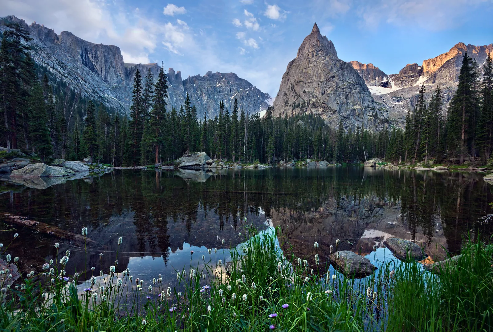
6. Monarch Lake to Crater Lake, Indian Peaks Wilderness, Colorado
Trip Overview
This varied trail gives you the best of what the Colorado Rockies have to offer. You’ll start at Monarch Lake and follow the path along cascading creeks through fields of wildflowers. Be on the lookout for deer and moose as you weaving through open meadows, and enjoy the waterfalls that break up the long trail. This trail takes you almost eight miles into the Indian Peaks Wilderness, culminating at two alpine lakes, Mirror Lake and Crater Lake. These stunning lakes are set in glacially-carved bowls at the base of Lone Eagle Peak, a strikingly photogenic mountain.
Trip Details
The trail starts at Monarch Lake where signs for the Cascade Creek Trail lead you through forests of conifers and aspen along a rushing riverbed. After almost 6.5 miles, you take a right onto the Pawnee Pass trail and ascend over rockier terrain to Mirror Lake. After taking in the serenity of Mirror Lake, hop on a single track trail on the west side of the lake to access Crater Lake, only a bit further up the trail.
This long, moderate hike is worth packing your overnight gear. The Crater Lake cirque, over seven miles into the wilderness, offers ample opportunities to camp in the shadow of Lone Eagle Peak and Mt Achonee. There are many established campsites around the lake, however, choose carefully. It is best to follow Leave No Trace principles and select a site that is at least 100 meters from the water’s edge. For experienced hikers and scramblers, the adventure continues. Lone Eagle Peak is a class 4 scramble, and there are several other ridgelines and summits to be explored.
Permits, Fees, and Reservations
Permits are required for overnight trips in the Indian Peaks Wilderness and reservations can be made in advance. Vehicles must pay a fee to park at trailheads in the Arapaho National Recreation Area. Interagency/National Park passes are accepted.
When to Hike
July through October. Wildflowers fill the meadows in the late summer, and aspen groves provide pops of orange in the autumn months. Trail conditions for both summer and winter travel are available to the public.
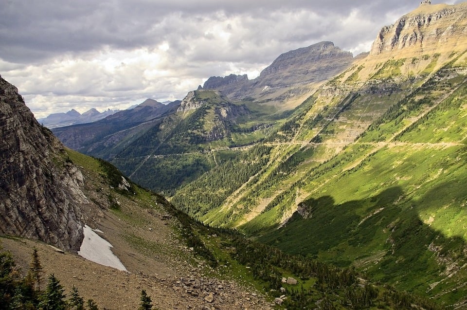
7. Highline Trail, Glacier National Park, Montana
Trip Overview
This narrow trail seems to be cut directly out of a cliffside, teetering precipitously on the edge of the west slope of the Continential Divide. It provides sweeping mountain views of the Logan Pass area of Glacier National Park. You trek across narrow footpaths, next to steep drop-offs, and past a mountain chalet. Mountain goats and bighorn sheep feel at home in the landscape, so watch for animals moving across the rocky walls.
Trip Details
The Highline Trail begins at Logan Pass, the highest elevation in the park accessible by car. Arrive early, this trailhead gets busy, and the parking lot is often full during summer days. If you plan to complete the entire one-way hike, park at “the Loop” on the Going-To-The-Sun Road and take the free shuttle to the Logan Pass trailhead.
Once on the trail, you will quickly encounter the Garden Wall, infamous for its narrow path and steep drop-offs. The Park Service has installed a hand-cable to ease any fear of heights. The beginning of this hike is extremely popular, but crowds dissipate with each mile traveled. Continue up towards Haystack Pass on the flanks of Mount Gould; this is a great place to stop for lunch as you’re surrounded by striking rock walls and jagged peaks.
As you descend along the Garden Wall, the Granite Park Chalet comes into view. Shortly, you arrive at a junction with the Glacier Overlook trail — a one-mile steep climb to a breathtaking view of the Grinnell Glacier. If you have the energy, this is an excellent addition to an incredible hike. Finally, descend the Granite Park Trail for over four miles back towards your car.
Grizzly bears are common in Glacier National Park, so make sure to carry bear spray while hiking!
Permits, Fees, and Reservations
An entrance fee* of $35 per vehicle, or $20 per individual, is required to enter the National Park.
*The America the Beautiful National Park Pass would cover this entrance fee.
When to Hike
July through September. This trail retains snow late into the summer and can experience closures at any time of year. Check trail conditions before attempting to hike this trail.
8. Paria Canyon and Buckskin Gulch, Vermillion Cliffs Wilderness, Utah
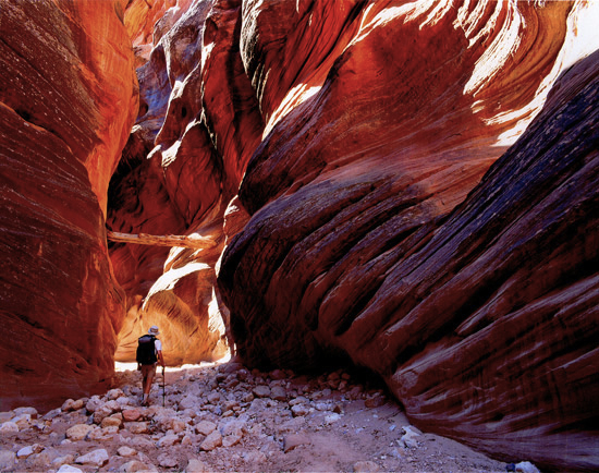
Trip Overview
Narrow slot canyons, carved by thousands of years of water running through towering sandstone walls, define this unique slice of the USA. Light dances in waves across the red, orange and golden rock. If you run your hand across the polished surface of the Navajo sandstone, you can feel the path the water took as it rushed through these small spaces. This is Paria Canyon, set deep in the Vermillion Cliffs Wilderness in the iconic canyon country of Southwestern Utah. Natural arches and rounded amphitheaters tower above you as you trek along the sandy wash into this harsh desert environment.
Trip Details
This non-technical slot canyon is an exceptional introduction to desert hiking and backpacking. Paria Canyon runs from the White House Campground to Lee’s Ferry, totaling 38 miles one-way. However, it is accessible from four trailheads: Wire Pass, White House, Buckskin Gulch, and Lee’s Ferry. Multi-day backpacking itineraries and mileage change depending on which trailhead you choose. If you want a day hike to experience the splendor of Buckskin Gulch, the longest and deepest known slot canyon in the world, you can hike into the canyon from the Wire Pass trailhead (3.4 miles roundtrip).
There are limited water sources along the canyon, so plan your route accordingly. Carry the appropriate amount of water for the duration and season of your trip. Summer temperatures require hikers to carry significantly more water.
Flash floods during rainy weather are incredibly dangerous — check the weather conditions before embarking on this hike!
Permits, Fees, and Reservations
You need a permit for any overnight stay in Paria Canyon, so make reservations in advance. These permits are highly competitive, as only twenty overnight visitors are allowed to access the canyon each day. If you want to day hike into Paria Canyon, fill out a self-serve day-use permit at the trailhead.
When to Hike
This trail is open year-round, but April through June and September through November are the best times to visit. Summer can bring high temperatures and flash flood risk, while winter can bring incredibly cold temperatures.
Explore Paria Canyon on a Guided Trip!
Guided Paria Canyon backpacking trips are available and are a stress-free, exciting way to do this hike. The tour company handles gear, snacks, and lunch, and provides a professional, knowledgable guide so you can focus 100% on enjoying your adventure. Read more…
9. Teton Crest Trail, Grand Teton National Park, Wyoming
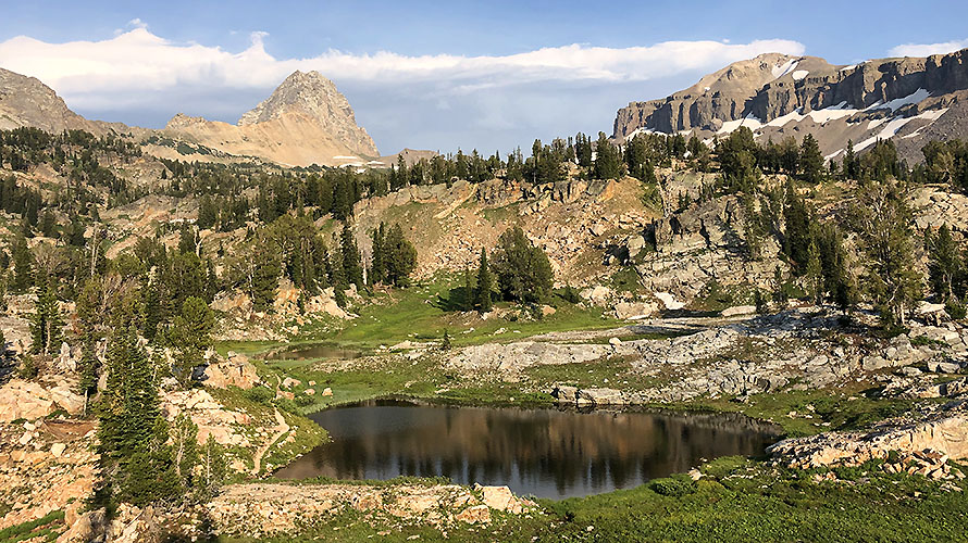
Trip Overview
The Teton Mountains are a wild range teeming with wildlife – from moose and grizzly bears, to elk and wolves. It is part of the Greater Yellowstone Ecosystem, which is one of only two intact ecosystems in the lower 48. This ecosystem is home to an abundance of wildlife and plant species. The Teton Crest Trail has the best characteristics of a high-alpine route — winding up and across mountain passes, around jagged ridgelines, and past turquoise alpine lakes. The colors burst as lupine and paintbrush sprinkle high meadows. The golden light of sunrise on granite peaks is complemented each day by the fading purples of the alpine glow across the Teton Range.
Trip Details
This trail is no small task and requires a lot of planning to make this hike a reality. There are many itineraries each hiker can take to follow the Teton Crest Trail, making this a customizable adventure for many skill levels.
Permits, Fees, and Reservations
Backcountry permits are required for all overnight trips in Grand Teton National Park, and this trip is no exception. Secure campsites in advance by making reservations. The park also holds two-thirds of backcountry sites for walk-in permits; however, these permits are in high demand during the summer seasons.
When to Hike
This trail is almost entirely in the high country, so it is best hiked in July through September for lowest snowpack levels. These conditions vary year-to-year, so check snow levels in advance. Microspikes and an ice ax may be necessary well into August during heavy snowpack years.
Explore the Tetons on a Guided Trip!
Guided Tetons backpacking trips and Tetons llama treks are available and are a stress-free, exciting way to explore these stunning mountains. The tour company handles gear, snacks, and lunch, and provides a professional, knowledgable guide so you can focus 100% on enjoying your adventure. Read more…
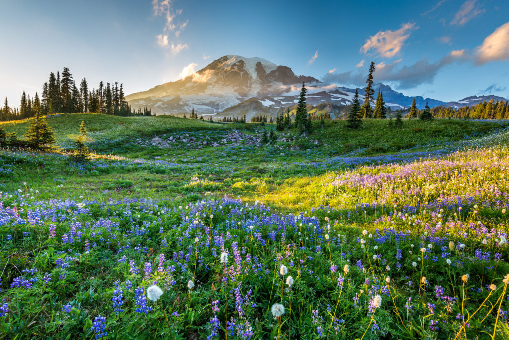
10. Wonderland Trail, Mount Rainier National Park, Washington
Trip Overview
This 93-mile loop should be on every backpacker’s radar. It is an epic trail that circumnavigates Mount Rainier, one of Washington’s five volcanoes and the most glaciated peak in the contiguous United States. The fact that this trail doesn’t actually climb Rainier fails to make it easier — it’s a long trek across varying terrain with over 22,000 feet of elevation gain. But for those up to the challenge, this trail offers a little bit of everything. It traverses through old-growth forest, across meadows sprinkled with wildflowers, and up and over rocky ridgelines to gain other-worldly views of an ever-changing mountain. You hike through geologic history, up and over old lava flows and through glacially-carved valleys. As you gaze out on scenic vistas, breathe in the fresh air of temperate rainforests, and feel the mist of numerous waterfalls, you’ll thank yourself for taking on the challenge.
Trip Details
You don’t have to commit to the full 93 miles if you want to hike the Wonderland Trail. The trail is split into segments — each one offering a unique experience and a changing landscape. For the experienced hiker, sections of the trail can be tackled in one day or on shorter backpacking trips.
For those aiming to hike the entire loop in one go, be sure to secure a reservation in advance. Food caches are available to lighten the weight and make the trip more enjoyable, so plan ahead.
Permits, Fees, and Reservations
A permit is required to camp at all backcountry campsites in Mount Rainier National Park. Make reservation requests for the upcoming summer season from March 15 – April 1st. If you wish to hike the entire loop, applying for a reservation during this time is the best chance to secure campsites. The National Park Service continues to fill permit requests after this time; however, fewer options will be available. A limited number of walk-in permits are available, so if you wish to hike only part of the Wonderland trail, this may be an option. During peak season (late-July through Labor Day), permits are harder to come by without a reservation.
An entrance fee of $30 per vehicle or $15 per person is required to enter the National Park. Annual park passes are available which cover entrance fees for all federally-operated lands.
When to Hike
Like many hikes in the Washington high country, this trip is best made in late summer, from late-July through mid-September. Late-July through mid-August put on the best wildflower show, but also see the highest populations of insects and people. After Labor Day, crowds thin, water levels drop for more accessible crossings, and temperatures are milder. High snow levels can limit access to trailheads in all other seasons, so check road statuses before you go.
Explore Mount Rainier on a Guided Tour!
Multi-day Mount Rainier hiking tours and Rainier day hikes are available and are a stress-free, exciting way to explore these stunning mountains. The tour company handles gear, snacks, and lunch, and provides a professional, knowledgable guide so you can focus 100% on enjoying your adventure.
Wildland Trekking Hiking Adventures
As the world’s premier hiking and trekking company, Wildland believes in connecting people to fantastic environments in amazing ways. Wildland Trekking Company offers an array of incredible hiking and trekking experiences in 9 states and 11 countries. Read more about our world-class destinations.
To learn more about our guided backpacking trips and all of our award-winning hiking vacations, please visit our website or connect with one of our Adventure Consultants: 800-715-HIKE.

