
3 Best Appalachian Trail Day Hikes in North Carolina
Grab your daypack, put on your hiking shoes, and be prepared to follow those classic white trail blazes. Your Appalachian Trail hiking adventure begins here.
| Trip | Difficulty | Hours | Miles |
| Charlies Bunion | Moderate-Strenuous | 5 | 8 total |
| Wesser Bald Fire Tower | Moderate | 1 | 2.2 total |
| Max Patch | Easy-Moderate | <1 | 1.5 total |
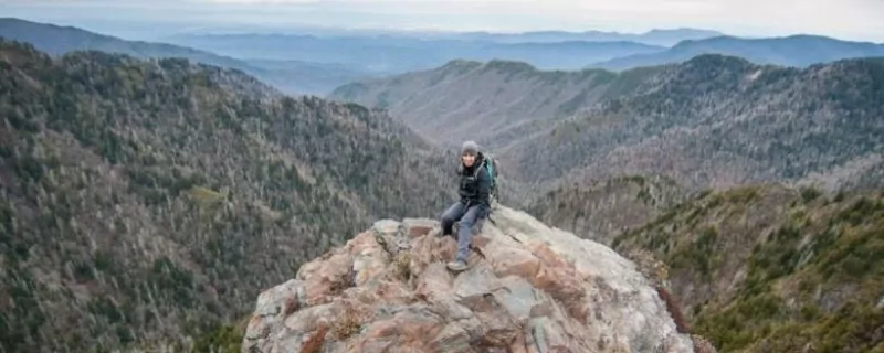
1. Charlies Bunion via the Appalachian Trail at New Found Gap
Have you ever wanted to hike on the Appalachian Trail? Have you also wanted to do a little hiking in Great Smoky Mountains National Park? Do you like a bit of a challenge?
If your answer is yes, then Charlies Bunion is a hike not to miss. The trailhead is located on the North Carolina and Tennessee border where President Franklin Roosevelt declared the national park’s formation in 1934. It is an eight-mile out-and-back hike beginning at the New Found Gap parking area in the heart of Great Smoky Mountains National Park.
History
Horace Kephart named Charlies Bunion before the formation of Great Smoky Mountains National Park. Kephart was surveying the area with Charlie Conner in 1929 when he declared that this area would be named after Charlie. Rumor has it that this rock formation resembles Charlie Conner’s bunion, hence the name Charlies Bunion.
The “bunion” formation was created by two separate events. First, in 1925, a massive forest fire scorched the land. Then, in 1929, massive rainstorms carried away the soil as there was no longer any vegetation rooting it in place, leaving this rocky outcrop.
What to Expect: Weather and Terrain
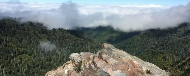
This moderate hike along the infamous AT is not to be missed no matter the season. It is a ridgeline hike that follows the border of both Tennessee and North Carolina with spectacular views on clear days; however, don’t cancel your hike if you arrive at the trailhead and cannot see two feet in front of you.
Many days this will be the case, but start hiking anyways. Three different phenomena might occur.
- After hiking the 1600 feet in elevation gain, the sun melts the clouds away and you get a view of beautiful blue skies as far as you can see.
- After hiking the 1600 feet in elevation gain, you might get above the clouds and have a 240-degree view of blue sky and a carpet of clouds.
- After hiking 4 miles, you arrive at Charlie’s Bunion and still cannot see two feet in front of you, but the experience of getting to the Bunion will be one you will remember for years to come.
The trek to Charlies Bunion will test your physical fitness. It is a hike that feels like it is uphill both ways; it is likely your lungs will scream going uphill and your hips and knees may complain going downhill. But all of this communication from your body reminds you that you are alive.
Never worry about being too hot along this hike. Whatever the temperature in town is, subtract ten to twenty degrees to get the expected temperature on this hike. As I write this piece, it is 73 degrees in Gatlinburg, TN; 71 degrees in Cherokee, NC; 55 degrees at the New Found Gap parking area; and 59 degrees at Charlies Bunion.
What to expect: Sights Along Trek
Three miles into the hike towards Charlies Bunion, Icewater Springs Shelter will be located on your right. Be sure to take this quick detour and check out the backcountry Appalachian Trail shelter. Find the journal located inside the shelter and take a quick read. AT thru-hikers jot down their thoughts and also communicate with each other in this journal as they head towards Maine. Look for the bear hang, a cable and pulley system where backpackers hang their food at night to keep the black bears safe. Also, see if you can find the privy, a backcountry toilet.
What to Expect: Seasons

What can you expect to see during the different seasons when hiking along the Appalachian Trail to Charlies Bunion?
- In the winter, there will be ice on the trail and maybe some snow. The trees are often decorated with ice, and there are more scenic viewpoints. Be sure to bring warm layers including a windproof layer and microspikes.
- In the spring, you will be sharing the trail with AT thru-hikers (hikers that started at Springer Mountain in Georgia and are hiking the Appalachian Trail all the way to Katahdin, Maine). Be sure to say hi as they pass by. As far as sights to see, you will see the greening of the mountains. The earth is coming alive. Wildflowers will be blooming. The birds will be singing. The bears will be foraging. Be sure to carry hiking spikes in your daypack because there may still be ice on the trail.
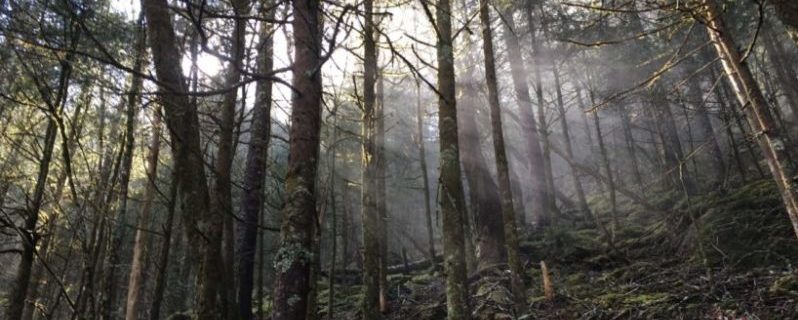
- In the summer, the forest will be full and dense. Moss and ferns will be abundant. Snakes will be active and often sunning themselves. Be sure to pack a jacket; temperatures can get chilly.
- In the fall, be prepared for a crowded trail. The fall colors are spectacular. Be on the lookout for mushrooms of all shapes, sizes, and colors. Remember to take only pictures, as picking vegetation is illegal in Great Smoky Mountains National Park.
Charlies Bunion is a hike full of variety. Do you like rocky trails with some big steps up and down? Do you like strolls through fir forests with the smell of the holidays surrounding you? Do you like panoramic views? Do you want to see what an Appalachian Trail Shelter looks like? If you answer yes to any of these questions, then I recommend that you hike from New Found Gap to Charlies Bunion and back.
Getting There
To get to the Charlies Bunion Trailhead, drive on Newfound Gap Road to Newfound Gap parking lot which is 13.2 miles from Sugarlands Visitor Center or 16 miles from Oconaluftee Visitor Center. The trailhead is to the left of the overlook, at the end of the parking lot near the restrooms. Free parking is available at the Newfound Gap trailhead.
From Cherokee, NC:
Head north on US-441 N for 19 miles; Newfound Gap will be on the right.
From Gatlinburg, NC:
Head south on US-441 N for 16.5 miles; Newfound Gap will be on the left.
Recommended Gear List
- Day Pack filled with the 10 Essentials
- Hiking specific shoes
- Trekking Poles
- Water
- Lunch and snacks
- Microspikes during late fall, winter, and spring
- Camera
Permits, Fees, Reservations…etc.
There is no fee to enter into Great Smoky Mountains National Park.
There is no permit required for day hiking in Great Smoky Mountains National Park.
FYIs
- Pets are not allowed on this trail
- Check for road closures during inclement weather
- Map of Great Smoky Mountains National Park
- GPS Coordinates: 35.610867, -83.425017 // N35 36.652 W83 25.501
- Elevation at New Found Gap: 5,049 feet
- Peak elevation along on this route: 6,222 feet
- Elevation at Charles Bunion: 5,565 feet
Weather
Check out the weather in both Gatlinburg, TN and Cherokee, NC to get an idea of the weather at Charlies Bunion. Remember, it will be 10-20 degrees cooler at Charlies Bunion than in the cities.
Hike Charlies Bunion-Jump Off Day Hikes with a Guide
Guided Charlies Bunion – Jump Off Day Hikes are available and are a stress-free, exciting way to do this trip. The tour company provides gear, meals, and a professional guide so you can focus 100% on enjoying your adventure.
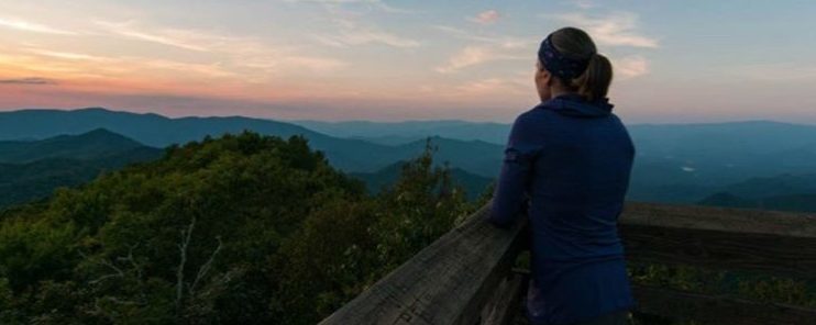
2. Wesser Bald Fire Tower via the AT at Tellico Gap
Do you like to work hard for a view? Are you an early riser? Or are you a night owl? Or do you prefer to wake after the sunrise, go for a hike, and to be all cozy on the couch after dinner? If you answer yes to any of these questions, then Wesser Bald Fire Tower is the perfect hike for you.
Sunrise
If you wake before sunrise, grab your camera, headlamp, breakfast, water, and a thermos of your favorite hot beverage and start the unyielding uphill hike to the Wesser Bald Summit. You will want to beat the sun to the top, so give yourself an hour because this hike is straight up. When you get to the top, take a sip or two of water, climb the metal fire tower to the wooden observation deck, and prepare for a spectacular sunrise. Be sure to put your coat back on; the temperature will dip as soon as the sun crosses the horizon.
Mid-day
For those who are not early risers, anytime during the day is a great time to hike through the hardwood forest to climb the Wesser Bald Fire Tower. The Nantahala forest is a temperate rainforest, so pack your rain gear. Rain is a possibility at any time. Once you reach the top of Wesser Bald and climb the 30-foot tower, you will experience a phenomenal 360-degree view of the Nantahala Forest and Little Tennessee River Valley. The lake in the distance is Fontana Lake, which is also along the path of the Appalachian Trail.
Sunset

Sunset hikes are my personal favorite. The colors are simply breathtaking as the sun falls below the horizon. Bring a blanket, a jacket, a hat, and a warm beverage and lie down and watch the stars twinkle in the night sky. It is dark! This makes the top of the tower a perfect place for finding constellations. Just don’t forget your headlamp for your nighttime trek back down the mountain.
Getting There
From Franklin, NC:
Take NC-28 North out of Franklin, follow 11.2 miles.
Turn left onto Tellico Road, follow for 8.3 miles.
Tellico Road turns slightly right and becomes Otter Creek Road.
The trailhead is 0.2 miles down Otter Creek Road.
The parking area is at the railroad ties.
From Bryson City, NC:
Follow Us-74 W 21 miles towards Murphy.
Turn right onto Wayah Road and follow for 5 miles.
Turn left onto Otter Creek Road.
The trailhead is in 3.8 miles on Otter Creek Road.
The parking area at the railroad ties.
From Murphy, NC:
Follow US-74 E 26 miles towards Bryson City.
Turn right onto Wayah Road, follow for 5 miles.
Turn left onto Otter Creek Road.
The trailhead is in 3.8 miles on Otter Creek Road.
Park at the railroad ties.
Recommended Gear List
- Day Pack filled with the 10 Essentials
- Hiking specific shoes
- Trekking Poles
- Water
- Snacks
- Jacket
- Camera
- Headlamp
FYIs
- Recommended Map
- GSP Coordinates: 35.268480, -83.572368 // N35 16.092 W83 34.344
- Leashed dogs allowed
- No water source at the top
- Check for seasonal trail and road closures on the USFS Nantahala National Forest site
- 4-wheel drive vehicle recommended in winter
Permits, Fees, Reservations…etc.
There is no permit required for day hiking in the Nantahala National Forest.
Weather
Wesser Bald Fire Tower Weather
Hike North Carolina Appalachian Mountains with a Guide
Ready to try hiking and sleeping in a tent but would like an easy introduction into backpacking? Guided Appalachian Portered Trips are available in North Carolina, and are a stress-free, exciting way to explore the mountains of North Carolina. Hike with light day packs while porters provide and carry in and out top-of-the-line the gear, set up and break down camp, and cook exceptional meals.
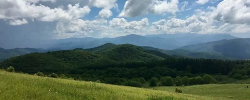
3. Max Patch via “Blue Blaze” Trail to the Appalachian Trail
Do you want to stretch your legs and get your blood pumping but are limited on time? Are you trying to convince your best friend that hiking is fun? Or do you want to take your four-year-old for a family-friendly hike with spectacular views? I suggest heading to Max Patch Mountain for a short day hike with a big reward.
Landscape
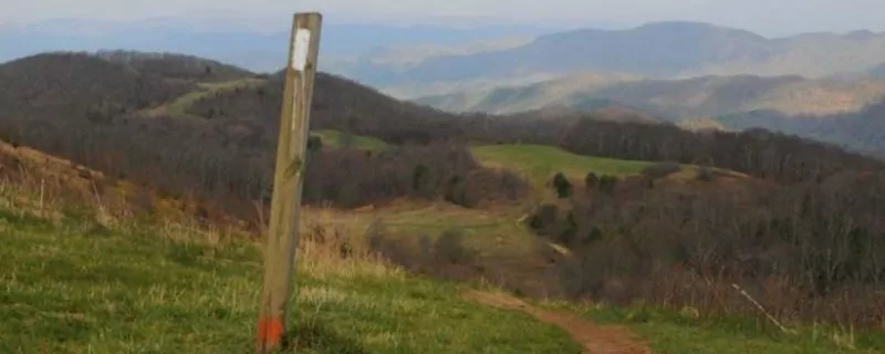
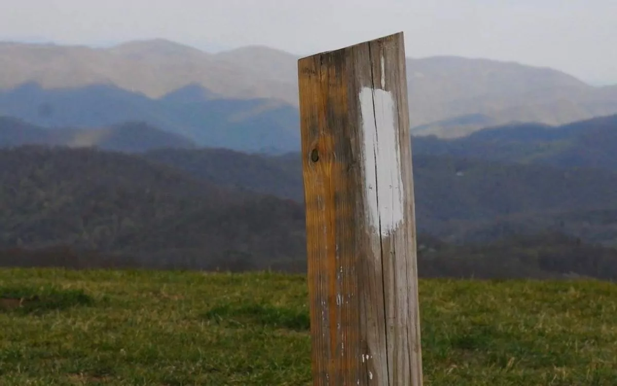
On Max Patch Mountain, you will not find the famous AT trail markers on trees. Instead, you will follow wooden posts painted with the infamous 2×6 vertical white blaze. Trees are scarce at the top, giving you an unobstructed 360-degree view of seemingly endless mountains. Max Patch is a 4600-foot mountain of grassy meadows.
What to expect: Seasons

In spring and summer, wildflowers will be in abundance along your hike to the top of Max Patch. See if you can find some wild blueberries and blackberries in the summer. In the fall, autumnal colors spread in every direction. In the winter, if you have access to a four-wheel drive vehicle, consider a snowy hike for simply stunning views.
Views
Max Patch is located in the Pisgah National Forest. While lounging in the mountain meadows on top of Max Patch, be sure to look south and cast your eyes upon the Great Smoky Mountains. Turn to the east and gaze at the majestic Mount Mitchel. To the west, you will see the Black Mountains far off in the distance.
History
Max Patch has an interesting history. In the 1800s, this mountain was cleared and used as pasture for raising livestock. Then, in the 1920s, this cleared mountain was used as a landing strip for airplanes.
Without upkeep from the Forest Service and The Carolina Mountain Club, Max Patch would slowly turn back into a wooded forest. Therefore, mowing and controlled burns are occasionally performed.
What to Expect

Max Patch is a popular hike among locals as well as out-of-state visitors. Don’t be surprised when you are not alone when visiting this little wonder along the Appalachian Trail in North Carolina.
Pack a picnic. Put on some sunscreen. Grab your camera and a jacket. It will be about 10 degrees cooler at the top. The wind might be blowing, so bring a kite along on this day hike adventure. Be a kid again and go play in the wind.
Getting There
Max Patch parking area is off of FS 1182 (Max Patch Road).
From Asheville, NC:
Take I-40 W to NC-209 N in Iron Duff (exit 24), 26.6 miles.
Follow NC-209 N and Max Patch Road to State Route 1182 for 44 miles.
From Hot Springs, NC:
From Hot Springs take NC 209S for 7.3 miles to SR 1175.
Go south on SR 1175 for 5.3 miles. Take SR 1181 about 3.5 miles to the end.
Turn right on SR 1182 for 1.5 miles
Recommended Gear List
- Day Pack filled with the 10 Essentials
- Water
- Snacks
- Jacket
- Sunscreen
- Camera
FYIs
- Recommended Map
- Leashed dogs allowed
- GPS Coordinates https: 35.796467, -82.962517 // N35 47.788 W82 57.751
- No water source at the top
- Check the Forest Service website for road closures
- 4-wheel drive vehicle recommended in winter
Permits, Fees, Reservations…etc.
There is no Permit required for day hiking in the Pisgah National Forest.
Weather
Blue Ridge Mountains Day Hikes with a Guide
Love hiking but want to end the day with a hot shower and a soft, comfy bed? Guided Blue Ridge Mountains Inn-Based Tours are available. These are multi-day hiking experiences with exceptional accommodations, fantastic meals, and a professional Blue Ridge Mountains hiking guide. All tours include local transportation, lodging, meals, and park entrance fees.
Or check out all of Wildland Trekking’s trips that include hiking on the Appalachian Trail!
Wildland Trekking Hiking Adventures

As the world’s premier hiking and trekking company, Wildland believes in connecting people to fantastic environments in amazing ways. The Blue Ridge Mountains in North Carolina offer an array of incredible hiking and trekking experiences. Wildland Trekking provides a variety of different types of hiking and backpacking adventures in North Carolina. Read more about our North Carolina trips.
To learn more about our guided backpacking trips and all of our award-winning hiking vacations, please visit our website or connect with one of our Adventure Consultants: 800-715-HIKE

