
Best Great Smoky Mountains National Park Hikes
Jump to:
We put out a poll on various social media platforms asking local hikers for their opinion on the best hike in Great Smoky Mountains National Park. Hands down, the most popular reply was a hike on Mount LeConte to the LeConte Lodge. We would whole-heartily have to agree.
Mount LeConte
I have personally lost count of the number of times that I have summited Mount LeConte. I have hiked to the top in all four seasons and all types of weather: sun, rain, and fog. Some days, the trail is dry; other days, it is wet and slippery. And in the winter and early spring, ice lines the uphill path to the summit.
Mount LeConte, reaching 6,593 feet, is the third-highest peak in the Great Smoky Mountains National Park. Here is an interesting fact: Mount LeConte is entirely in Tennessee from base to peak. Therefore, it is the state’s highest peak, rising from its base near Gatlinburg. While you hike up this grand mountain, you can feel the air cooling as you near the top. The lowest temperature ever recorded here was -32°F, and the highest temperature was 85°F. Daily temperatures are gathered and filed by NOAA coop volunteers and lodge staff employees.
This mountain is biologically diverse. Depending on the trail you choose, your hike might start in a green tunnel of rhododendron and mountain laurel. Regardless of your path, your hike will end in a spruce and Fraser fir forest. Be sure to inhale deeply and enjoy the crisp, fir smell as you walk through this magical forest.
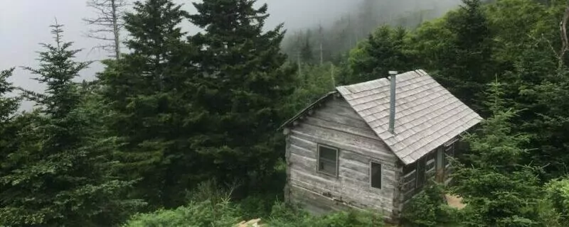
Mount LeConte is also known for having the highest-elevation inn in the Eastern United States and the only lodge in the Great Smoky Mountains National Park. Construction of LeConte Lodge began in 1926 before the formation of the Park in 1934. Not only is the LeConte Lodge nestled on one of the highest peaks in the Appalachian Mountains, but it is also completely off-grid. Oil-filled lanterns light dark rooms. Propane and wool blankets warm bodies. Dishes are washed by hand. As night falls, the sound of nature fills the air; the moon and stars illuminate the night sky.
Trails on Mount LeConte
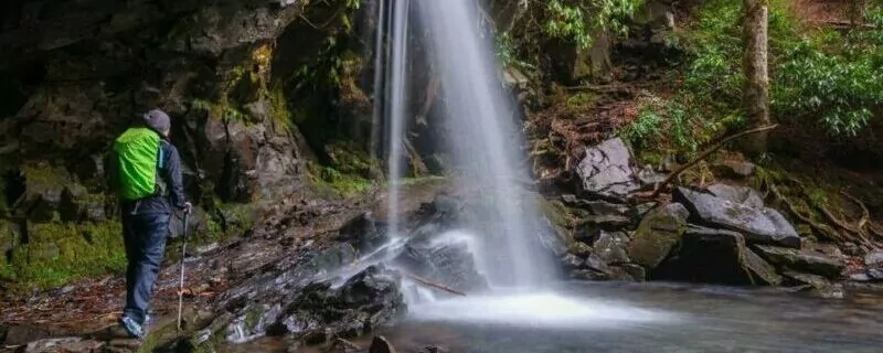
There are five (well, technically six, if you include Brushy Mountain Trail) different hikes up Mount LeConte to the LeConte Lodge: Alum Cave Trail, The Boulevard Trail, Bullhead Trail, Rainbow Falls Trail, and Trillium Gap Trail. Everyone has their favorite; however, the shortest and most popular hike to the top is the Alum Cave Trail.
No matter which trail you choose to summit Mount LeConte, you will not be disappointed. You will be greeted with a heart-pounding and lung-burning hike as you feast your eyes on endless natural beauty. The air smells green, fresh, and clean. Your soul will be soothed and your mind quieted as you lose yourself in the wonders of the Great Smoky Mountains National Park.
| Trip | Difficulty | Miles (one-way) | |
| Alum Cave Trail | Moderate-Strenuous | 5.5 miles | |
| The Boulevard Trail | Strenuous | 8 miles | |
| Bullhead Trail | Strenuous | 7.2 miles | |
| Rainbow Falls Trail | Strenuous | 6.9 miles | |
| Trillium Gap Trail | Strenuous | 6.9 miles |
Explore Your World. Award Winning Hiking Guides
1. Alum Cave Trail

Trail Overview
Alum Cave is popular: extremely popular. It is the shortest yet steepest path to the top of Mount LeConte at 5.5 miles. You must arrive early at one of the two trailhead parking lots off Newfound Gap Road to avoid the crowds. Here, you will begin the 2,560-foot climb. Some websites label this trail as moderate; others, as strenuous. Regardless, your heart will be pounding, and your lungs will gasp for air as you ascend towards this summit.
Trail Description
Alum Cave Trail to Inspiration Point
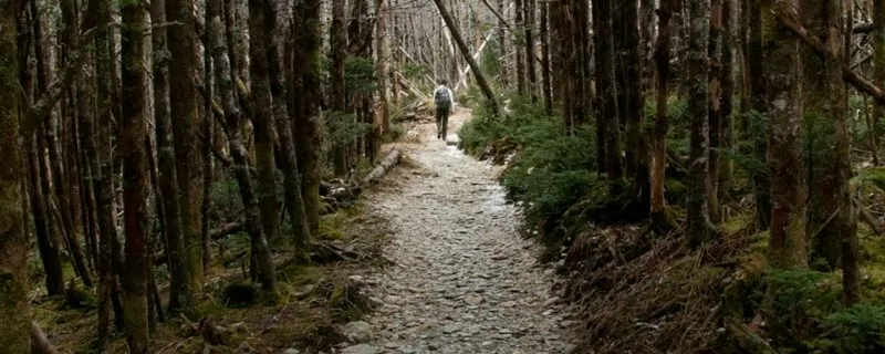
From the parking lot, Alum Cave Trail crosses over the Oconaluftee River and immediately begins a gradual, uphill trajectory through rosebay rhododendron and mountain laurel. The trail meanders besides Styx Branch stream, occasionally crossing over it. 1.3 miles into the hike, Alum Cave Trail crosses over Styx Branch for the last time. At this point, the trail becomes steeper as you climb the stairs leading through Arch Rock.
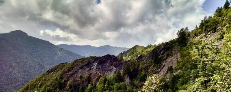
The terrain becomes rocky as the climb continues to Inspiration Point, a heath bald. Inspiration Point is an excellent spot to catch your breath, eat a snack, and take in the views. Little Duck Hawk Ridge is the rocky ridge to the west. Try and locate the “Eye of the Needle,” a hole located near the top of the ridge. Then, look to the northeast and view Myrtle Point. Myrtle Point is “the place” to catch sunrise at the top of Mount LeConte.
Alum Cave Bluffs
Once rejuvenated, continue uphill towards Alum Cave Bluffs about a mile away (2.2 miles from the trailhead.) Interestingly, Alum Cave Bluffs is not a cave but a concaved bluff about 80 feet in height and 500 feet in length. From 1838 to 1854, the Epsom Salts Manufacturing Company mined Epson salt from the Alum Cave Bluffs. During the Civil War, the Confederate Army mined saltpeter to manufacture gunpowder.
Alum Cave Bluffs is another fantastic place to rest, offering terrific views and a bit of shelter if it is raining. In the winter, huge icicles dangle from the top ledge. Be cautious when icicles are present on warm days, as these icicles can break off and come crashing to the ground. Startled expressions, often in the forms of screams, are heard from those nearby.
Alum Cave Bluffs to Gracie’s Pulpit
At this point, most of the crowd turns around and heads back down to their cars. For the hiker heading to the top, the trail only gets steeper. Be on the lookout for Gracie’s Pulpit, a small rocky outcrop just 0.4 miles from Alum Cave Bluffs, which marks the halfway point to LeConte Lodge. Gracie’s Pulpit is named after Gracie McNicol who, as a nurse, moved to Maryville, Tennessee, from Alaska at the age of 62. She then climbed Mount LeConte 244 times: 155 on foot and 89 by horseback. Her first climb was at the age of 63; her last, by horseback on her 92nd birthday!
For the next two miles, the trail hugs the side of the mountain and is defined by narrow rock ledges and periodic cable handrails. Sections of the trail have fairly steep drop-offs, so use caution, especially when ice is present. I highly recommend micro-spikes in icy conditions.
LeConte Lodge
You know you are nearing the top when the smell of “Christmas” is in the air. The terrain changes once again and now becomes a fir forest consisting of both Fraser and spruce firs. Here, the trail flattens a bit. Often fog or mist lingers in the forest, creating a magical enchanted feeling. The smell of fir and sense of enchantment renew your energy as you continue towards the summit.
Soon, you will come to a junction. Alum Cave Trail officially ends here. Take a right and shortly, you will arrive at the LeConte Lodge. It is great place to relax, use the restroom, refill your water bottle, or even purchase a hot beverage or a sack lunch. However, the lodge is NOT the summit. High Top is the true summit, less than a half a mile away. There are no vista views at the very top; instead, a large pile of rocks (called a cairn) marks the summit just off the main trail.
You can find views at Cliff Top (6,555 feet) and Myrtle Point (6,200 feet). These are comparatively short hikes from the LeConte Lodge. Join many of the LeConte Lodge residents as you head to Cliff Top for a magnificent sunset when Mount LeConte is not in the clouds.

Stay the night at the lodge or the LeConte backcountry shelter (advanced reservations are needed for both places) and wake before the sun. Walk to Myrtle Point with your camera and coffee for a spectacular sunrise. Or beat the crowds (as well as find easy trailhead parking) and hike up Alum Cave Trail to Myrtle Point to catch the sun as it wakes for the day.
Alum Cave Trail is a doable day hike for most hikers at 11-miles round trip. Take your time, and rest when needed. Drink plenty of water, and eat often. The accomplishment of summiting will be rewarding even if you end up hiking into the clouds.
Getting There
Please note that Highway 441 Newfound Gap Road is subject to closures during the winter months due to ice and snow. For current road conditions, please refer to the Great Smoky Mountains National Park website.
Head north about 23 miles on Hwy 441, past Newfound Gap Overlook parking area. The two Alum Cave Trail parking areas will be about 5 miles from Newfound Gap Overlook on your right.
Head south on Hwy 441, Newfound Gap Road. The parking areas will be on the left, about 8.5 miles past the Sugarland’s Visitor Center.
2. The Boulevard Trail
Trail Overview
This trail has views! Therefore, the Boulevard Trail has been one of my long-time favorites. It is a narrow, rolling ridgeline that crosses between Mount LeConte and the main crest of the Smokies. Like all trails to the top of Mount LeConte, this route is uphill. Even though this hike starts at an elevation of 5,049 feet and has a net elevation gain of 1080 feet, you will actually climb a total of 3,000 feet in elevation with all the ups and downs. The average elevation gain is 385 feet per mile.
Trail Description
The Boulevard Trail via the Appalachian Trail
The trailhead for this route is located at Newfound Gap on Highway 441. Newfound Gap is located in the center of the Smoky Mountains National Park and situated on the border of North Carolina and Tennessee. You will see the Rockefeller Memorial as you leave the parking lot and head into the woods. President Franklin D. Roosevelt formally dedicated the Great Smoky Mountains Nation Park at this site on September 2, 1940.
This route to the summit of Mount LeConte starts on the Appalachian Trail. Follow the AT signs north from the New Found Gap parking lot and walk along this legendary trail for 2.7 miles. Tennessee is on your left, North Carolina on your right, as you steadily climb towards the intersection where the Boulevard Trail meets the AT. At an elevation of around 6000 feet, you might be gasping for air, requiring breaks to catch your breath as you head to the summit of Mount LeConte.
The first nice place to catch your breath comes about 2/3 of a mile from the trailhead. Here, when clouds do not engulf the trail, you will enjoy a spectacular view of the North Carolina side of the Great Smoky Mountains National Park. Another mile down the trail, stop to catch your breath once again, as you look northwest to a view of Mount LeConte and Myrtle Point—your ultimate destination.
Soon, the Boulevard Trail will intersect with the Appalachian Trail on your left at a “T” junction. Turning right, staying on the AT leads you to Charlie’s Bunion and many miles (and months) later, to Katahdin, Maine. Instead, take a left at the “T” junction for the Boulevard Trail heading to Mount LeConte.
Jump-off Trail
For a quick side adventure along the way to Mount LeConte’s summit, hike the Jump-off Trail found on the right, just 0.10 miles from the turnoff onto the Boulevard Trail. The Jump-off is a short, half-mile trail that dead-ends at a fantastic view of Charlie’s Bunion and upper Greenbrier Cove. This trail is not officially a National Park trail; however, it is marked with an official sign.
The Boulevard Trail to Myrtle Point
As you continue the hike to Mount LeConte, you will remain at elevations between 5,500 and 6,500 feet. Wildflowers line the trail in all seasons except winter. In the colder months, ice and snow often forms along the edges. You will see abundant views as you follow the ridgeline until you enter the evergreen forest of red spruce, balsams, and Fraser firs.
The spur trail to Myrtle Point branches from the Boulevard Trail two-tenths of a mile from Mount LeConte’s summit. Myrtle Point offers nearly 360-degree panoramic views and is a great spot Mount LeConte to watch a sunrise from Mount LeConte.
Mount LeConte’s summit is unusual: it is known as High Top. You will see no scenic views, but instead, a large pile of rocks called a cairn. Snap a photo and document your accomplishment of reaching the summit. Then, continue to the LeConte Lodge to refill your water container and relax in a rocking chair.
Before you embark on your return hike, check out Cliff Top for another magnificent view. You can find the spur trail across from the LeConte Lodge. This is “the place” to capture a memorable sunset.
The hike along the Boulevard Trail to Mount LeConte’s summit will not disappoint. Views are aplenty. The trail length and difficulty is the perfect match for a full-day on the trail. Parking is easy to find at Newfound Gap. Solitude will be in abundance, even on the most popular days in the Park. Overnight stays at the Mount LeConte Shelter or LeConte Lodge are possible with advance reservations. Any difficulty you may encounter during your hike along the Boulevard Trail will be pleasantly off-set by the spectacular views.
Getting There
Please note that Highway 441 Newfound Gap Road is subject to closures during the winter months due to ice and snow. For current road conditions please refer to the Great Smoky Mountains National Park website.
Head north about 21 miles on Hwy 441, to Newfound Gap Overlook parking area. The parking area is on the right.
Head north about 12 miles on Hwy 441, to Newfound Gap Overlook parking area. The parking area is on the left.
3. The Bullhead Trail
Trail Overview
The Bullhead Trail has been on my “to hike” list for a few years now. I have hiked all the other trails up to Mount LeConte’s summit but, unfortunately, in November 2016, there was a massive fire in the Great Smoky Mountains National Park. The Bullhead Trail was severely damaged. No one was predicting when or if the trail was set to reopen. Sadly, I had missed my opportunity to hike the Bullhead Trail. Until…
Thanks to the hard work of trail crews, Bullhead reopened on October 25, 2018. I put hiking shoes on my feet, donned my pack on my shoulders, and hit the trail. However, I did not have high expectations for this trail. Other hikers and countless articles reported that the Bullhead Trail was long, steep, and nearly viewless. The 7.2-mile hike existed in a monotonous rhododendron tunnel. I guess I was about to find out.
Trail Description
Prepare for a long day of strenuous hiking if tackling the Bullhead Trail is on your to-do list. There are two other options if you prefer a loop hike. Most hikers prefer to hike up to Mount LeConte’s summit via Rainbow Falls Trail or the Trillium Trail and then down the Bullhead Trail. All options have high mileages, so prepare appropriately with plenty of food and water. Extra layers are always a good idea. At over 6500 feet in elevation,the top of Mount LeConte. brings in temperatures that are 10-20 degrees cooler than elsewhere in the Park.
The Old Sugarlands Trail to the Bullhead Trail
The Bullhead Trail begins at the Cherokee Orchard Trailhead, which is also the Rainbow Falls Trailhead. For this reason, parking can be tricky because many hikers and tourists venture into the woods to view Rainbow Falls. Never fear, crowds will not be found on the Bullhead Trail. Additionally, there is an auxiliary parking area a little further up the road. Both parking areas are located along the Roaring Fork Motor Nature Trail, a one-way street.
To hike the Bullhead Trail, you must trek along the Old Sugarlands Trail for just under half a mile before turning left onto the Bullhead Trail. These trails are all marked with signage. The Old Sugarlands Trail, an old wagon road connecting the Sugarlands Visitor Center with Cherokee Orchard, starts at the locked gate near the entrance to the Rainbow Falls parking lot.
The Bullhead Trail to the Pulpit
Gone is the leisurely stroll in the park once you make the left turn onto the Bullhead Trail. The trail now heads up and up and up. Total elevation gain will be near 4,000 feet.
Three miles into the hike you will arrive at a large rock cairn built by the Civil Conservation Corps in the 1930s. “The Pulpit,” also known as “The Bullhead Lookout,” was the best place for a view before fires cleared the line of sight. This structure allowed hikers to climb up and see over the rhododendron forest to lay their eyes upon Brushy Mountain and the Greenbrier Valley. Now, the cairn is unnecessary. There are views aplenty along most of the trail. In fact, my hike was extremely slow because countless times, I stopped to stare in awe and proclaim that this was now my favorite trail.
The Bullhead Trail to the Summit
Bullhead Trail dead-ends into the Rainbow Falls Trail at just over six miles. To visit the LeConte Lodge or reach Mount LeConte’s summit, follow Rainbow Falls Trail into the fir forest. You will find the Lodge in about 0.6 miles. From this point, you can access the Boulevard Trail to reach Mount LeConte’s true summit or the spur trails to Cliff Tops and Myrtle Point.
In my opinion, the Bullhead Trail is a must-do trail. Hike it sooner than later before the rhododendron regrow into their full glory. However, reconsider hiking this trail on windy days. Falling trees are a possibility. Between the 2016 forest fire and the Wooly Adelgid, an aphid-like insect that is killing the hemlocks by draining the trees of their sap, dead trees are abundant in this area. But on windless days, grab your gear and explore the Bullhead Trail.
Getting There
Please note that Highway 441 Newfound Gap Road is subject to closures during the winter months due to ice and snow. For current road conditions please refer to the Great Smoky Mountains National Park website.
From Cherokee, North Carolina
From Cherokee, take 441 North through the Great Smoky Mountains National Park to Gatlinburg. Enter into town and then turn right on the Historic Nature Trail, which turns into Cherokee Orchard Road. Around 2.7 miles, the Boulevard/Rainbow Falls parking lot will be on your right.
From Gatlinburg, North Carolina
From the Sugarlands Visitor Canter, take 441 North into town and then turn right on the Historic Nature Trail, which turns into Cherokee Orchard Road. Around 2.7 miles, the Boulevard/Rainbow Falls parking lot will be on your right.
4. Rainbow Falls Trail
Trail Overview
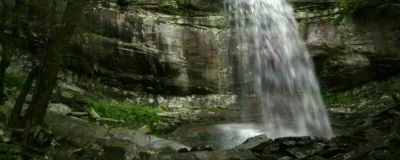
The Rainbow Falls Trail is believed to be the oldest route to Mount LeConte’s summit. It is rocky and steep, with an elevation gain of nearly 4000 feet over 6.7 miles. So, why would you choose to trek this difficult trail when there are shorter and less steep options to the summit? You choose this route to the summit to survey the lush vegetation, to gaze at amazing views, and to see the highest, single-drop waterfall in the Great Smoky Mountains National Park.
Trail Description
The Rainbow Falls Trail is extremely popular and is heavily trafficked for the first 2.7 miles to where the falls are located. The falls are just over 80-feet tall. On sunny days, a rainbow often forms in the mist giving Rainbow Falls its name. Even explorers only hiking to the falls will experience the effort it takes to climb this trail. The trail gains more than 1500 feet in elevation from the parking lot to the falls.
Park at the Rainbow Falls/Bullhead parking lot to access the Rainbow Falls Trail easily. The trail follows LeConte Creek, which is also known as Mill Creek because of the large number of gristmills that operated along this stream. The trail twists and turns, periodically taking you across the creek by way of foot-logs.
The Seasons of the Rainbow Falls Trail
Pick any season and you will enjoy trekking along the Rainbow Falls Trail. It is an excellent route to follow up to Mount LeConte’s peak in the summer months. The trail leads through dense forests and rhododendron/mountain laurel tunnels. Even on the hottest of days, the temperature are colder than on the exposed Bullhead Trail.
During the fall, the forest is swathed in autumnal colors. In winter, when the temperatures plummet below freezing, the lower portions of the trail leading to the falls are covered in ice, and Rainbow Falls exhibits impressive ice structures.
Springtime brings blooming rhododendron, mountain laurel, and sand myrtle, as well as an abundance of wildflowers. Springtime also brings plentiful rain. Immediately after a good rain, when the sun peeps out from behind the clouds, the awesomeness of Rainbow Falls is at its full glory.
Rainbow Falls to Mounte LeConte summit
After stopping to enjoy the falls, you will continue to climb up the mountain. As the trail leads up towards Mount LeConte’s summit, you will experience cooler temperatures and witness vast views of the Great Smoky Mountains. At 5.4 miles, there is a side trail leading to Rocky Spur. It is a short side-trip that you do not want to skip. This spur trail leads to an outcrop where you can feast your eyes upon the Roaring Fork Valley.
Rainbow Falls Trail and the Bullhead Trail intersect around mile 6. Be sure you turn left to continue towards the summit. Alum Cave Trail will also intersect with the Rainbow Falls Trail. Be sure to stay straight at this intersection. You will know when you are near the top when you reach the LeConte Lodge on your left. Cliff Tops is easily accessed across from the LeConte Lodge. Cliff Tops is known for its spectacular sunsets.
To reach Mount LeConte’s true summit, continue straight past the LeConte Lodge and also the LeConte Shelter. You will find High Top, Mount LeConte’s true summit, after the LeConte Shelter on your right. You are now officially on the Boulevard Trail which, not only leads you to Mount LeConte’s summit, but also leads to Myrtle Point—the perfect place to catch a sunrise.
After relaxing atop Mount LeConte, most hikers return to their cars via the Bullhead Trail, making a nice loop. Both Rainbow Falls out-and-back and the Rainbow Falls/Bullhead loop are a long day of hiking, and weather conditions can change quickly. Be sure you pack plenty of food, warm layers of clothing, raingear, and a headlamp. Sleeping on top of Mount LeConte is an option but requires reservations either at the LeConte Lodge or the LeConte Shelter.
Getting There
Please note that Highway 441 Newfound Gap Road is subject to closures during the winter months due to ice and snow. For current road conditions please refer to the Great Smoky Mountains National Park website.
From Cherokee, North Carolina
From Cherokee, take 441 North through the Great Smoky Mountain National Park to Gatlinburg. Enter into town and then turn right on the Historic Nature Trail, which turns into Cherokee Orchard Road. Around 2.7 miles, the Boulevard/Rainbow Falls parking lot will be on your right.
From Gatlinburg, North Carolina
From the Sugarlands Visitor Canter, take 441 North into town and then turn right on the Historic Nature Trail, which turns into Cherokee Orchard Road. Around 2.7 miles, the Boulevard/Rainbow Falls parking lot will be on your right.
5. Trillium Gap Trail
Trail Overview
Those familiar with the five different hikes up Mount LeConte know that the Trillium Gap Trail is special for two reasons: Grotto Falls, and llamas. The gradual elevation gain of just over 3400 feet, the trail length of 6.5 miles, the scenic views along the way, and the rocky terrain make this the perfect hike for those who want a little challenge with great rewards.
Yes, I did say that this trail was known for the llamas. The LeConte Lodge is remote, with no roads leading to the top. Before the lodge opens in March every year, a helicopter drops supplies off near the summit. For the rest of LeConte Lodge’s season, a team of eight llamas is employed to haul supplies to the top. Three times a week—Monday, Wednesday, and Friday—these hard-working llamas bring food, supplies, and clean linens up to the Lodge and then carry the dirty linens and trash back down to town.
Meeting the llamas is a real treat. Each llama has their own personality. I witnessed that they can be extremely picky eaters. The llamas begin their day no later than 6 am. By lunchtime, they typically arrive at the lodge, where they are rewarded with a pancake treat. However, not all llamas like pancakes. The llamas are offered carrots and apples to round out their snack. Amazingly, I also watched as a few llamas stuck up their noses and refused these sweet treats. However, to meet the llamas and watch their eating antics, you must hike to the top of Mount LeConte.
Trail Description
Trillium Gap Trail to Grotto Falls
Like the Rainbow Falls Trail, the Trillium Gap Trail is popular because many visitors come to see Grotto Falls. Trailhead parking is limited, so get there early to snag a parking spot. After parking at the Trillium Gap parking lot, walk across the street just beyond the parking area to access the trailhead.
Immediately, you will be immersed in a thick hemlock forest. As you meander along the Trillium Gap Trail through this old-growth forest, Roaring Fork Creek—one of the steepest streams in the park—will be along your side. Wildflowers are abundant in this area. In the spring, the rare and beautiful white and yellow trilliums can be spotted, giving this trail its name.
Your trek along Trillium Gap Trail to Mount LeConte’s summit will be a continuous uphill journey. However, after hiking 1.3 miles, you will be rewarded with a 25-foot waterfall named Grotto Falls. Trillium Gap Trail leads you directly behind the falls as you continue your trek up the mountain. Watch your footing as you walk behind this natural beauty; the path is slippery. In the winter, when temperatures plummet below freezing, ice and icicles are present.
Grotto Falls to Brushy Mountain
Once you past Grotto Falls, any crowd will be left behind. The trail becomes rockier and rockier; therefore, be extra careful with your foot placement. The trail also becomes steeper as you climb. Be on the lookout for the intersection with the Brushy Mountain Trail around 3.1 miles from the trailhead. Be sure to stay right to remain on Trillium Gap Trail.
I do recommend that you take the short (about one-third of a mile) hike to the summit of Brushy Mountain. It’s a great place to take a break, eat a snack, and enjoy the majestic view of Mount LeConte and the eastern side of the Great Smoky Mountains.
Trillium Gap Trail to LeConte Lodge
Once back on Trillium Gap Trail, you will start seeing Fraser firs as you gain elevation. You will eventually come to steps leading into a tunnel of fir trees. Then, you will pass a horse hitching post; horses are allowed on Trillium Gap Trail.
You are now near the summit. Mount LeConte Lodge will be on your right, but don’t stop here if your goal is to reach Mount LeConte’s true summit. Continue following the Trillium Gap Trail until it dead-ends into the Rainbow Falls Trail. Turn left here and walk the last three-tenths of a mile to reach High Top, Mount LeConte’s official summit. High Top, where a large cairn makes the summit, is 6.9-miles from the Trillium Gap Trail trailhead. You will find no views here, but majestic views are found at Cliff Tops and Myrtle Point.
Until November 14, 2019, the Trillium Gap Trail and associated parking lots are to be closed Monday 7 am through Thursday at 5:30 pm for trail reconstruction. Also, the Roaring Fork Motor Nature Trail is closed from December through mid-March. It is possible to hike the Trillium Gap Trail during winter; however, your will start with a road walk from the Rainbow Falls Trailhead to the Trillium Gap Trailhead, adding another 2 miles to your round-trip hike.
Getting There
Please note that Highway 441 Newfound Gap Road is subject to closures during the winter months due to ice and snow. For current road conditions please refer to the Great Smoky Mountains National Park website.
From Cherokee, North Carolina
From Cherokee, take 441 North through the Great Smoky Mountain National Park to Gatlinburg. Enter into town and then turn right on the Historic Nature Trail, which turns into Cherokee Orchard Road. Around 1.7 miles, the Grotto Falls parking lot will be on your right. The trailhead is at the far end of the parking lot.
From Gatlinburg, North Carolina
From the Sugarlands Visitor Canter, take 441 North into town and then turn right on the Historic Nature Trail, which turns into Cherokee Orchard Road. Around 1.7 miles, the Grotto Falls parking lot will be on your right. The trailhead is at the far end of the parking lot.
6. Brushy Mountain Trail
The LeConte Challenge
Once you have hiked the five main trails to Mount LeConte’s summit of 6593 feet (the third highest peak in the Great Smoky Mountains National Park), it is time for an even bigger challenge—the LeConte Challenge. You may also hear it called the LeConte24 or the Triple Summit. The goal of this challenge: hike all 45.7 miles of trails leading to and from Mount LeConte. You will summit Mount LeConte three times in 24 hours.
This year, on May 1, the Adams (three friends named Adam) completed the challenge in 23 hours and one minute. Their route was Boulevard to Trillium Gap, Bullhead to Rainbow Falls, Alum Cave to Brushy Mountain. Yes, this challenge includes hiking the Brushy Mountain Trail.
Brushy Mountain Trail Overview
Brushy Mountain Trail is not a trail that is typically listed as a route to or from Mount LeConte. As the unofficial sixth trail, it is the least-used route to LeConte’s summit. In fact, it is the only trail to or from Mount LeConte that I have not hiked.
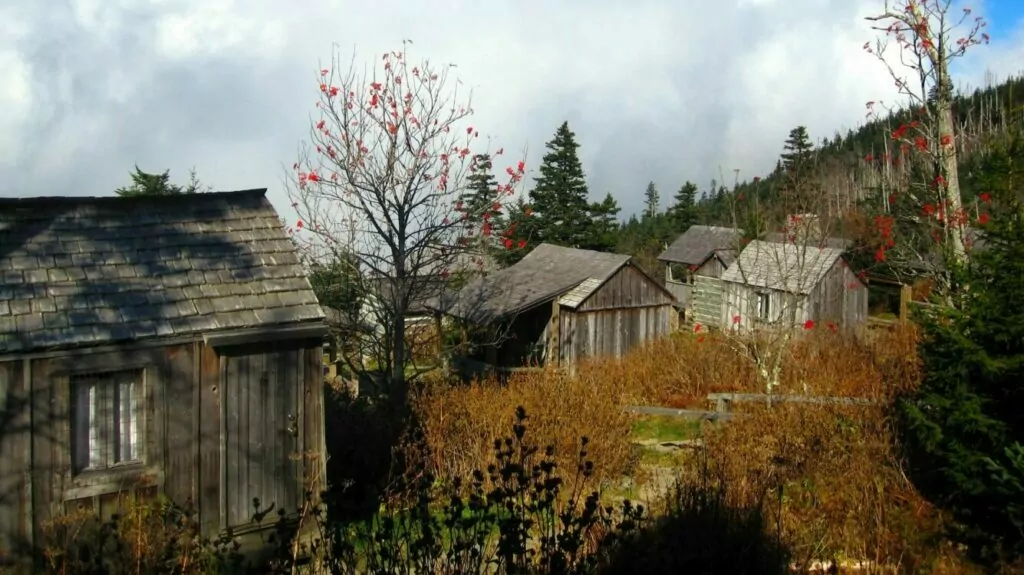
At 9.1 miles from the trailhead, Brushy Mountain is the longest route to Mount LeConte’s summit. This route also gains the most elevation. However, the elevation gain is gradual, so the overall hike is less steep than other trails to the top. The first few miles of the Brushy Mountain Trail is full of history. It has remnants of old homesteads, the Ownby Cemetery, and a historic farm site that is short (250 yards) spur trail away.
Getting There
Please note that Highway 441 Newfound Gap Road is subject to closures during the winter months due to ice and snow. For current road conditions please refer to the Great Smoky Mountains National Park website.
This hike begins from the Porters Creek Trailhead in the Greenbriar area.
From Gatlinburg, North Carolina
This hike begins from the Porters Creek Trailhead in the Greenbriar area.
Wildland Trekking Hiking Adventures

As the world’s premier hiking and trekking company, Wildland believes in connecting people to fantastic environments in amazing ways. The Great Smoky Mountains National Park offers an array of incredible hiking and trekking experiences. Wildland Trekking provides various multi-day hiking and backpacking adventures in the Great Smoky Mountains. Read more about our Great Smoky Mountains Hiking Tours.
To learn more about our guided backpacking trips and all of our award-winning hiking vacations, please visit our website or connect with one of our Adventure Consultants: 800-715-HIKE
