
The Best Beginner Backpacking Trips In the Canadian Rockies
The Canadian Rockies should be on every hiker’s bucket list: snow-capped peaks, ancient glaciers, pine forests, and abundant wildlife keep even the most seasoned hikers coming back year after year. There are many trails suitable for beginners and seasoned hikers alike.
The Canadian Rockies is home to seven parks, including four national parks. Each of them offers truly stunning and pristine scenery as the parks can be quite remote. Below are some of our favorite introductory trips to the area from 2-6 nights in length.
Before you go hiking in the Rockies
Hiking season in the Canadian Rockies begins when the snow melts, which can vary depending on the severity of the previous winter. Trails at higher elevations may not be passable until well into late June or July, whereas trails that remain mostly in the valley bottom or forests can clear of snow as soon as mid-May.
For beginner backpackers, you’ll want trails that are well-established with a relatively modest elevation gain or loss, while still traveling through some of the most iconic landscapes of the Canadian Rockies, from pine forests to alpine basins and alongside turquoise lakes. Our favorite beginner-friendly trails are also well-signed and have facilities such as pit toilets, tent pads, and food storage to ensure the easiest camping experience.
One of the draws of hiking in the Canadian Rockies is the abundant wildlife you might see, including elk, moose, beavers, foxes, bighorn sheep, mountain goats, and of course, bears. It is important to educate yourself a bit on the dangers this wildlife can pose and to always carry and know how to use bear spray.
Getting there
The Canadian Rockies cover a large area and often have somewhat remote trailheads, upwards of one to two hours from the nearest town. Having the ability to drive to the trailhead, arrange a shuttle or opting for a guided hike are popular options for out-of-town travelers. The nearest city to fly into is Calgary, Alberta, and then trailheads begin near the small mountain towns of Banff, Canmore, Jasper, and Invermere.
Jump to:
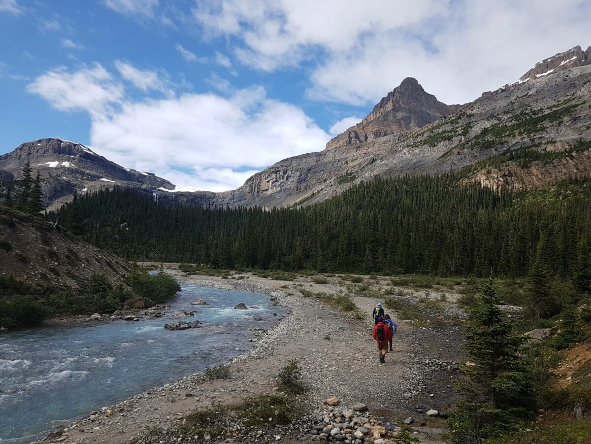
Iceline Trail and Emerald Lake Loop, Yoho National Park
- Mileage: 21.8 miles / 35km with options to go shorter
- Length: 3-4 days
- Elevation Gain/Loss: 3900 feet
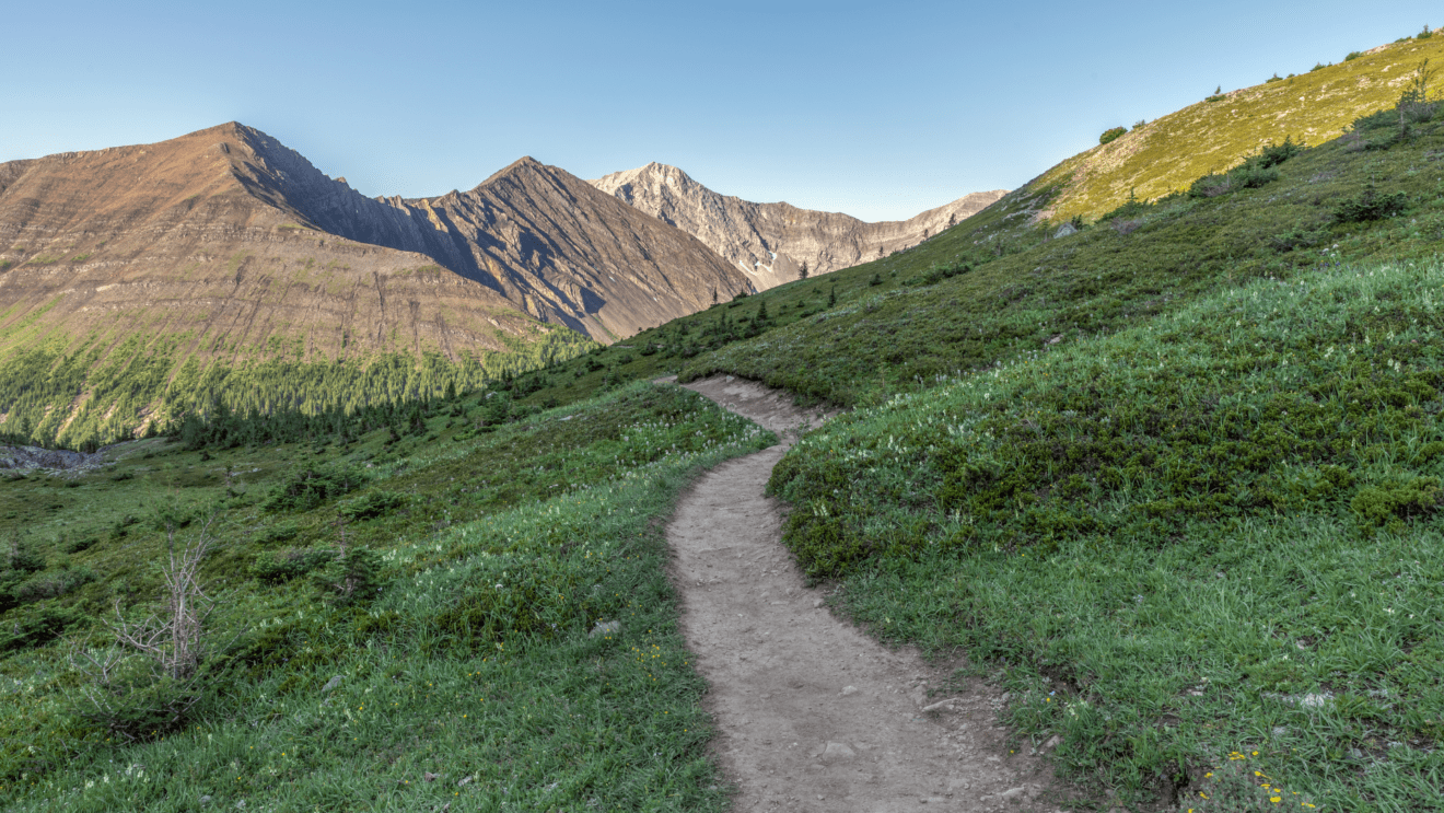
The Iceline Trail is one of the must-do hikes in the Canadian Rockies, often done as a short backpacking trip or long day trip (not recommended). The trailhead starts just an hour’s drive from the town of Banff. In Yoho National Park, the trail takes hikers from the forest-filled valley floor into the high alpine, traversing underneath 11,000-foot mountains, offering panoramic views of Takakkaw Falls and camping alongside the turquoise waters of Emerald Lake.
Why is it great for beginners?
The Iceline Trail is great for beginners due to the flexibility it offers, with an abundance of campground and trail options to fit your comfortable mileage for each day. Moreover, as one of the most popular hikes in the area, the trail is very well-maintained and easy to travel, while still taking hikers through a diversity of the iconic sights of the Canadian Rockies like waterfalls, lakes, and high-alpine basins.
Logistics and permits:
For all backpacking trips in Canada’s National Parks, you will need to obtain a National Parks Pass, as well as a camping reservation. Camping reservations can be hard to obtain, especially for more popular trails, so be sure to book early or consider going on a guided hike. Sometimes cancellations open up, and there are many campsites to choose from in the area if your ideal itinerary isn’t possible. There is also a backcountry hut operated by the Alpine Club of Canada along the route, if camping reservations prove impossible.
Guided trip options:
Wildland Trekking offers a 4 day guided hike of the Iceline Trail as an all-inclusive guided backpacking adventure package with expert guides, gear, meals, and transportation. Click below to check out the itinerary and this year’s trip dates, then contact us to get started!
Lake Minnewanka and Alymer Lookout, Banff National Park
- Mileage: 15.5 miles / 25km
- Length: 2-3 days
- Elevation Gain/Loss: 2300 feet
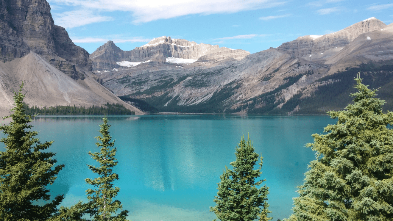
The turquoise waters of Lake Minnewanka flanked by the dramatic rocky mountains is a popular destination for sightseers to the Canadian Rockies. Just a short drive from the town of Banff, this trail is a great early-summer trip, perfect for families with some experience backpacking or for a more relaxed weekend trip.
Why is it great for beginners?
The Lake Minnewanka trail is great for beginner hikers, families, or those wanting a relaxed but still beautiful hike to do over the course of a weekend. The trail covers a modest distance, with many campsites along its length to choose from.
It is common for hikers to walk in, set up camp, and then spend the remainder of the day exploring or relaxing along the lakeshore. Additionally, there is the option to continue on to Alymer Pass, just a short day hike away, for spectacular views of Lake Minnewanka and the surrounding peaks from above.
Logistics and permits:
Like other hikes in Canada’s National Parks, you will need to obtain a National Parks Pass as well as a camping reservation. Reservations open in the winter prior to the summer hiking season and book up quickly so it’s important to plan ahead to allow you the best chance to get a permit. If you are unsuccessful, don’t fret – there are many cancellations and campsites will often become available. The trailhead starts just an hour’s drive from the town of Banff.
It is mandatory to travel in groups of four or larger between the dates of July 10th and September 15th, due to the potential for grizzly bears in the area.
Glacier Lake, Banff National Park
- Mileage: 10.5 miles / 17km
- Length: 2 days
- Elevation Gain/Loss: 1500 feet
Located on the Icefields Parkway, one of the most scenic drives in the world leads to this often forgotten hike. The Glacier Lake trail takes hikers from the Saskatchewan River Crossing – a historic meeting point of fur traders – through rolling terrain and pine forests towards Glacier Lake. Though most of the trail is in the forest, it has remained relatively uncrowded, and there is a high chance that you’ll have the lakeside campground at the end all to yourself, accompanied by views of the South Lyell Glacier.
Why is it great for beginners?
The hike to Glacier Lake is often recommended as an early-season hike as it is lower in elevation, as well as being great for introductory backpackers or families. Traveling a modest 5 miles out-and-back and gaining just 750 feet per day makes this trail accessible for a variety of skill levels as well as young children or teenagers who are new to the outdoors. Many locals to the Rockies will do this hike early season as a warmup for tackling bigger backpacking trips later in the summer.
Logistics and permits:
As Glacier Lake is in Banff National Park, you will need to ensure you have a National Parks Pass as well as obtain a camping reservation. Reservations open in the winter prior to the summer hiking season and book up quickly so it’s important to plan ahead to allow you the best chance to get a permit. The trailhead starts near Saskatchewan Crossing, a one and a half hours drive from the town of Banff.
Forks Backcountry Campground, Peter Lougheed Provincial Park
- Mileage: 9 miles / 15 km round trip
- Length: 1 night / 2 days (can be extended)
- Elevation Gain/Loss: 300ft
While the provincial parks are often overshadowed by the majesty and history of the National Parks, this trail is not to be missed and is one of the hidden gems in terms of distance and beauty. While the Forks Campground itself is not that picturesque, the hike to get there has fantastic views of Upper Kananaskis Lakes, and there are many options to hike just a little further for viewpoints down to Three Isle Lake – a stunning vista not to be missed.
Why is it great for beginners?
The Forks Backcountry Campground in Peter Lougheed Provincial Park is the perfect trail for a first-time backpacking trip or young families. The trail itself travels just over 4.5 miles one way to reach the Forks campground, with minimal elevation gain/loss along the route. The campground is well-setup and comfortable, and once you settle into camp, there is the option to tackle a short but steep climb to Three Isle Lake – a fantastic viewpoint that looks into an adjacent valley. During the fall this is a popular leaf peeping destination for viewing the larch trees change to their brilliant golden hue.
Logistics and permits:
The trail starts from the North Interlakes day area, roughly two hours drive from the city of Calgary. Campsite reservations can be made 90 days prior to the booking, and you will also need a Kananaskis Conservation Pass to display in your vehicle.
Tonquin Valley, Jasper National Park
- Mileage: 26.7 miles / 43km
- Length: 3 nights / 4 days
- Elevation Gain/Loss: 3000 feet
The Tonquin Valley is not to be missed for the beginner or intermediate backpacker wanting a more remote wilderness experience. Located in Jasper National Park, this northern section of the Rockies has a more distinct high-alpine feel, meadows, and slightly more rugged terrain than that of the trails closer to Banff. The trail has been popularized by photographs of the Ramparts, a group of rocky mountains sitting 3000 feet above Amethyst Lake.
Why is it great for beginners?
Though it is somewhat long in length, most choose to hike the trail over multiple days, resulting in a very approachable daily mileage. Additionally, over the course of the 26 miles, the trail gains just 3000 feet in elevation, traveling through rolling terrain with few challenging climbs or descents. Above all, there are many campsites to choose from, as well as some backcountry lodges that campers can stay in if they want more creature comforts.
Logistics and permits:
The Tonquin Valley is nearest to the small town of Jasper, a 3 hour’s drive along the stunning Icefields Parkway north of Banff. For this reason, it’s best for those who have more time to explore or want to experience a slightly more remote area.
As the Tonquin Valley is in Jasper National Park, you will need to ensure you have a National Parks Pass as well as a camping reservation. Reservations open in the winter prior to the summer hiking season and book up quickly so it’s important to plan ahead to allow you the best chance to get a permit. The best times to hike are generally late in the summer when the trail is drier and the bugs are less prevalent.
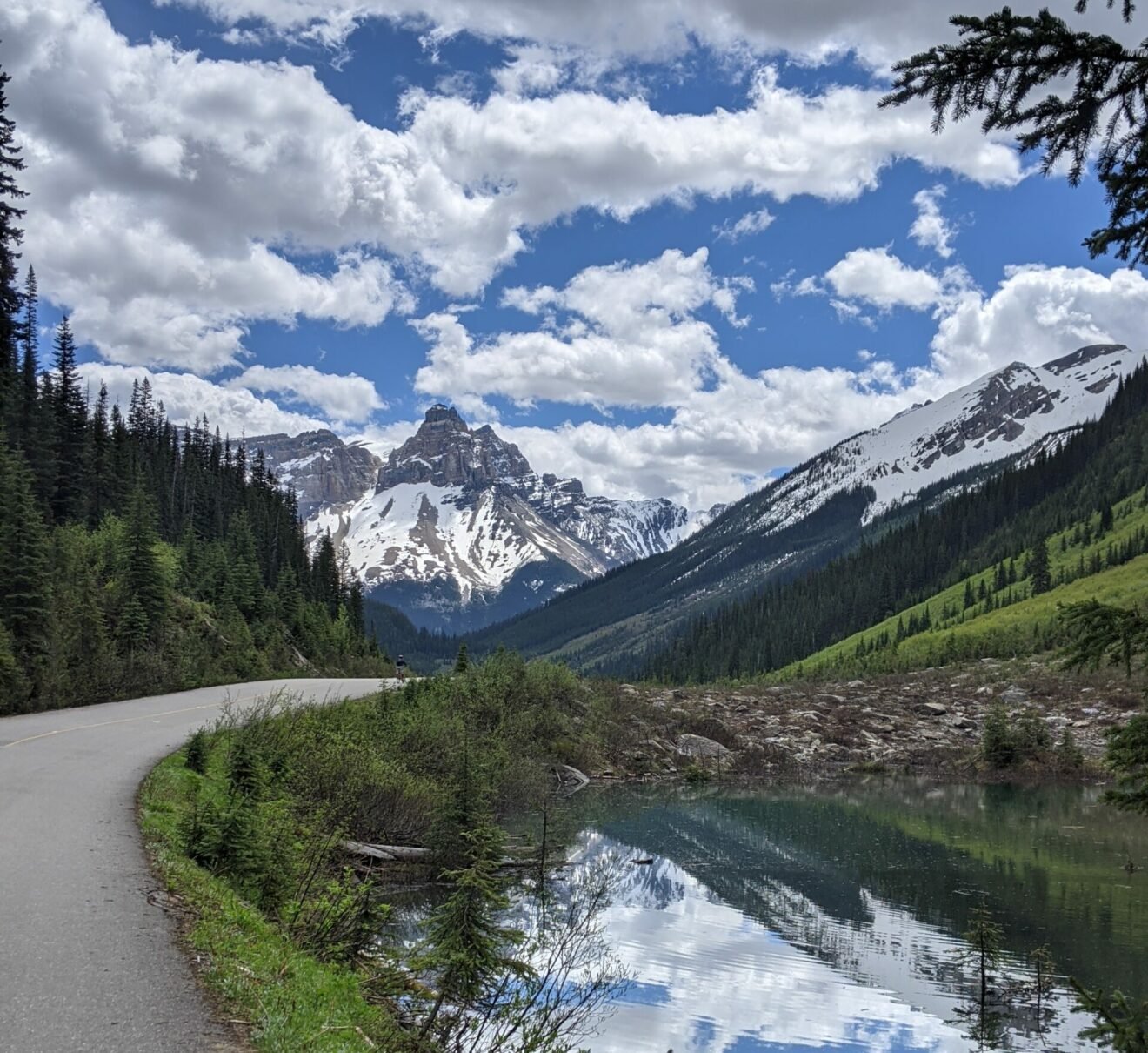
Rockwall Trail, Kootenay National Park:
- Mileage: 32 miles / 54km
- Length: 4 nights / 5 days
- Elevation Gain/Loss: 9000 feet
The Rockwall Trail is without a doubt one of the premier backpacking trips in the Canadian Rockies. Traversing nearly 40 miles, the trail starts in relatively lush pine forests before entering sub-alpine terrain and traversing underneath the ‘Rockwall’ – a dramatic 3000-foot high limestone fortress of peaks and hanging glaciers.
Depending on which way the trail is approached, hikers will either end or begin at Floe Lake, one of the most photographed lakes in the Rockies accessible only by hiking. Having done this hike multiple times, there is a reason we keep coming back.
Why is it great for beginners?
The Rockwall Trail is on the upper end of difficulty for a beginner backpacking trip, recommended for those who have a few trails already under their belt and a decent level of fitness. That said, don’t let the distance or elevation gain intimidate you – the Rockwall is a very approachable trail that is frequently traveled, straightforward to navigate, and has multiple campsites and trailhead options to shorten or lengthen the trip if needed. That said, we recommend going the whole distance, there isn’t a single part we’d want to miss!
Whichever direction you go on this point-to-point trail, the campsites are spaced perfectly apart so no day is too big in mileage or climbing / descending.
Logistics and permits:
As the Rockwall is in Kootenay National Park, you will need to ensure you have a National Parks Pass as well as a camping reservation. Reservations open in the winter prior to the summer hiking season and book up quickly so it’s important to plan ahead to allow you the best chance to get a permit. The best times to hike are generally late in the summer when the trail is drier and the bugs are less prevalent.
Because the trail is a point-to-point, we recommend traveling with two vehicles and to park one at each trailhead (Paint Pots or Floe Lake). It is also common for hiking groups who have just finished to hitch-hike or car shuttle with groups that are just beginning their hike.
Want to visit the Canadian Rockies but aren’t ready (or interested) in backpacking through? Let us take you on a 6 day inn-based tour of Banff, Kootenay, and Yoho National Parks.
