
Visiting Washington’s Hoh Rainforest
Of the many incredible places to visit in Olympic National Park, the Hoh Rainforest stands out to many visitors as a consistent favorite. The Hoh is one of four of the Olympic National Park rainforests and continues to be the most visited year after year. Nestled in the western side of the Olympic Peninsula, this corridor of life follows the Hoh River as it flows from its glacial origin high in the Mt. Olympic massif, to the wide, sweeping valley in lower elevations.
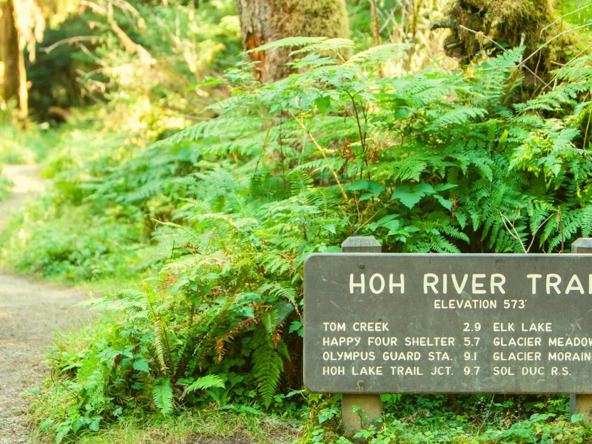
From Hwy 101, visitors drive 18 miles through a combination of National Forest and private land until reaching the National Park’s visitor center, campground, and trailhead. Bathrooms and restroom facilities await visitors ready for both day hikes and multi-day backpacking treks starting from the same trailhead. The Spruce Nature Trail and Hall of Mosses Trail allow guests to soak in the stunning old growth scenery and fertile forest without straying too far from civilization, while the Hoh River Trail encourages hikers to explore deeper into the forest on both day hikes and backpacking trips. This trail winds 17.4 miles along the forest floor following the Hoh River from the visitor center to the edge of the Blue Glacier, flowing off the shoulder of the tallest mountain in the park, Mt. Olympus. Along the way, hikers are met with a world of greenery and vibrant life. From carpets of ferns and mosses teeming with banana slugs, to ancient conifers fed by an average 140 inches of rain each year, the Hoh River trail guides you through biodiversity that will capture your curiosity.
Best time to visit
While the Hoh is spectacular year-round, there are seasonal considerations you should keep in mind when planning a trip. The reason for all the green is, of course, all the rain and the nearly 13 feet of rain comes mostly in the months of November through April. That being said, sturdy rain gear is an essential, year-round item for hiking this trail – especially for overnight adventures. The Hoh Rainforest weather in the months of July, August and September boasts average high temperatures in the 70’s Fahrenheit and draws the largest crowds, while the average highs lie in the 40’s during December, January and February.
Despite being completely geographically separate from the Cascade Range to the East, the Olympic Peninsula benefits from this natural barrier by being shielded from freezing temperatures moving south from the interior of Canada. The result is that the Olympic National Park rainforest temperatures rarely dip below freezing, preventing the multitude of delicate plant species from dying each winter. Cool temperatures and heavy rains are two characteristics of a temperate rainforest. Not to be confused with tropical rainforests, which lie close to the equator and provide a hot growing environment for mostly deciduous trees, temperate rainforests are dominated by large, old growth conifers and cooler temperatures. Outside of Alaska, the Olympic National Park rainforests are the only temperate rainforests in the United States.
Hiking the Hoh River Trail
Mile 3.2
One of the beauties of this trail is how untouched by humans this environment feels. This singular path, with the occasional campsite and ranger station are the only pieces of evidence that humans are around in an otherwise wild place. An often-overlooked aspect of human impact is auditory pollution. Hike anywhere near a popular flight path and you’ll be accompanied by dull jet engine groans as they meander across the sky. Sightseeing aircraft also frequent many hiking areas in the US, giving visitors spectacular views at the cost of wilderness silence. The Hoh River Trail boasts virtually no aviation-related noise pollution and has been listed as one of the quietest places in the United States by the independent research project, “One Square Inch.” Hiking 3.2 miles from the visitor center, just past the Mt. Tom Creek campsites, you may see a faint path heading up to the left. Around 305 feet above sea level, sitting on a fallen spruce log is a square red rock that marks the actual place where this silence was measured. If you find this place, please be respectful, leave no trace, and stay on established paths.
The Hoh River trail meanders on the north side of the river for most of the trail, guiding hikers through wonderful stands of both conifer and deciduous trees. Near the river big-leaf maple and alders dominate the ground cover. Big-leaf maples boast the largest leaf of any maple species in the world and attract heavy coverage from mosses and lichens on their trunks and branches. In the fall months, these massive leaves transform from light green to hues of yellow and orange as a sign of approaching winter. Witnessing the juxtaposition of these fiery colors with the greens of their clinging mosses is one of the benefits to autumn trips to the Hoh.
Mile 5
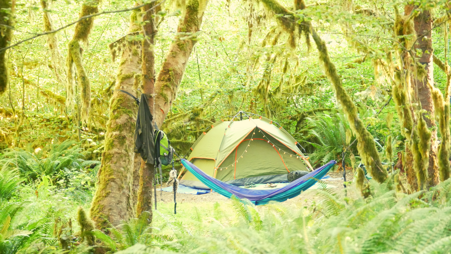
The appropriately named 5-mile island camp greets hikers with abundant camping options close to the river, as well as the first backcountry pit toilet. This is a popular first night camp for many, including Wildland Trekking, as they hike toward Mt. Olympus. The campsites here offer glimpse of a characteristic trait of many rivers in Olympic National Park, braided gravel bars. Each year, as the high elevation snow begins to melt, the Hoh River takes a new path toward the ocean. Based on factors like water volume and physical barriers, the river picks new avenues each season, resulting in wide, gravel strewn riverbeds, with multiple streams diverging and joining back together.
It is in this habitat that a keystone species of the Hoh is found, Chinook Salmon. These fish are spawned in the freshwater of the Hoh River, and almost immediately begin their journey to the ocean. After spending up to 7 years in the ocean, they return to the Hoh River and swim upstream until they reach their spawning grounds. It’s an arduous task and less than one fish in 1000 will survive to return to these same waters. Here, they will use their tails to create a depression in the gravel and deposit their eggs. By continuing this process up stream, they cover the previous site with gravel as they dig new sites. These are called Redds, and are often visible from the shore. It’s important to avoid stepping on these Redds when crossing streams and accessing gravel bars. Once the salmon have completed their spawning, they die and leave their nutrient dense carcasses as food for bears, eagles, otters, and more. Salmon acts as nutrient bridges between marine and terrestrial ecosystems, supplying key ingredients for life such as nitrogen to the rainforest soil. Also referred to as “King” Salmon, these fish range in size from 5 to 50 pounds! Specific Chinook Salmon caught in nearby rivers have weighed in just under 100 pounds.
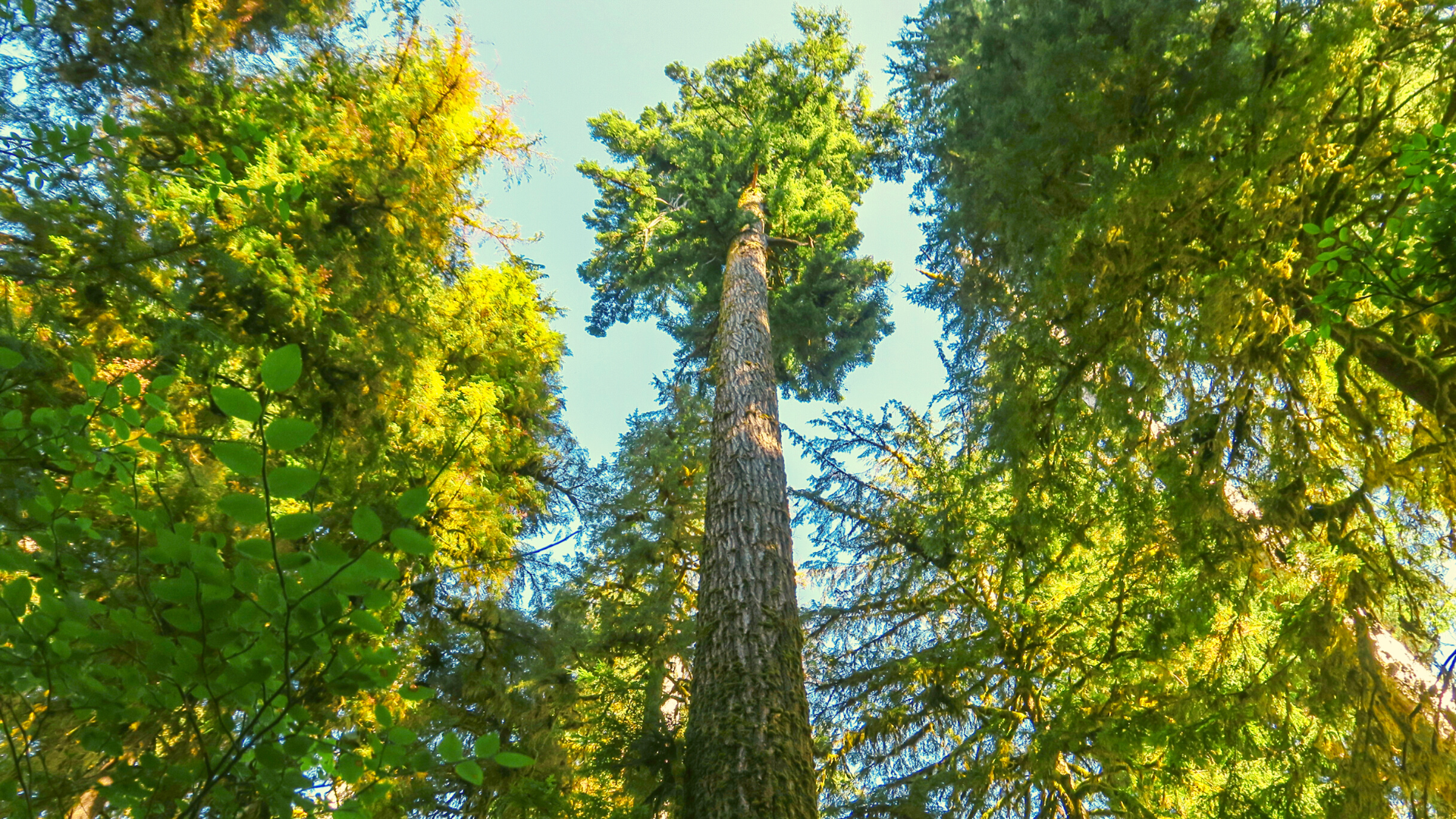
Moving uphill away from the river lie Douglas Firs, Western Hemlock, Red Cedar and Sitka Spruce. Douglas Firs, valued for their timber uses, grow unlogged in this forest to the ages of 600-800 years old. Specific Douglas firs have been recorded to age up to 1300 years old in small pockets. Western Hemlocks are shade resistant, meaning they need less sunlight than other conifers. Many of these droopy topped trees begin their life growing on “nurse logs,” decaying stumps and fallen logs that provide fertile growing conditions to new life. Western Hemlocks in the right conditions can grow over 1,000 years old, and upward of 170 feet. Western Red Cedars soar to heights of 200 feet or more with bases measuring up to 20 feet in diameter. These giants boast rot resistant wood, and water-resistant bark, making them a favorite building material for both native tribes and ship builders of the early 20th century.

Known as the “Tree of Life” by local tribes, Red Cedar wood is used in the building of everything from canoes to houses, while the fibrous bark is woven into thread and made into waterproof clothing. Sitka Spruce is the tallest species of tree in this ecosystem, growing to a staggering 250 feet. Together, these giants create a canopy of green that shades the river and forest floor and regulates the temperature.
Fungi act as the digestive tract for the rainforest and fulfil three main roles in the ecosystem. They act as a parasite and kill living things like trees and shrubs. After plants die, fungi help decompose the organic material, depositing nutrients in the ground as they do so. They also act as a nutrient transfer between plant species. The underground network of fungi, or mycelium, facilitates an exchange of nutrients between different tree and plant species, allowing the sharing of resources.
Mile 8.9
Almost nine miles in you’ll see the Olympus ranger station and campsite. This site is seasonally staffed with wilderness rangers checking permits and answering questions. Many of the buildings in the park, especially in the backcountry, are built using local materials. The ranger station is a great example of how rot resistant the Western Red Cedar is.
Proper food storage on this trail is very important for both human and animal populations. This is black bear territory, and while most are afraid of people, it is important to minimize any forced interaction with humans as much as possible. Some campsites along the trail have bear wires to suspend scented items and food from at night. Others require bear canisters that are available for rental from the wilderness center. Full-grown black bears can range in size from 250-600 pounds and will typically hibernate during the coldest months of the year. Their diet ranges from nuts and berries foraged from the forest floor to salmon and trout harvested from the rivers.
Bear sightings are more common deeper into the interior of the rainforest, as they emerge from their winter hibernation in search of food. While bear sightings are never guaranteed, you are more likely to see a bear in the early morning or late evening, foraging through huckleberry or salmon berry patches, looking to either start or finish their day with a sweet treat. If you see a bear, give them plenty of space and enjoy watching them from afar. If they approach you or if you find yourself in close proximity, make yourself know by talking to it and clapping your hands.
Berry season in the Olympics begins in mid-June and lasts through September. There are numerous, tasty berries to choose from in the middle of the summer including huckleberries, salmon berries, salal berries, elder berries, and blackberries. It is VERY important that you can correctly identify plants before eating anything you find in the backcountry. Despite the abundance of delicious food available, there are also plants that can seriously hurt or even, in the case of some mushrooms, kill you.
Mile 13.2
The trail begins to steepen as you cross the Hoh River and continue alongside Glacier Creek up a steep drainage. Be sure to look downstream as you cross Martin Creek a few miles later to get a glimpse of rolling cascades near its confluence with Glacier.
Mile 15
Elk Lake marks the final campsite for many, allowing campers to shed their heavy overnight gear and opt instead for a day hike to the glacier. A little less than two miles up from Elk Lake lies a trail washout. The Park Service has installed a primitive wooden ladder, and rope that extends down the 100-foot slope, known as the Jemrod Gully Ladder. Navigating this ladder with heavy backpacking gear can prove a significant challenge and is why many opt to day-hike this section from Elk Lake. Less than a mile after this section you will arrive at the final established camp, Glacier Meadows, equipped with a pit toilet and a number of sites.
Mile 17.6
Shortly after Glacier Meadows, you’ll reach a split in the trail. The left fork will take you to the lateral moraine of the Blue Glacier, and the right will take you to the terminal moraine. Glacial moraines are rock and soil sediment that builds up as the ice moves back and forth over time. Visiting both moraines is well worth the effort, just remember to get back to camp before dark.
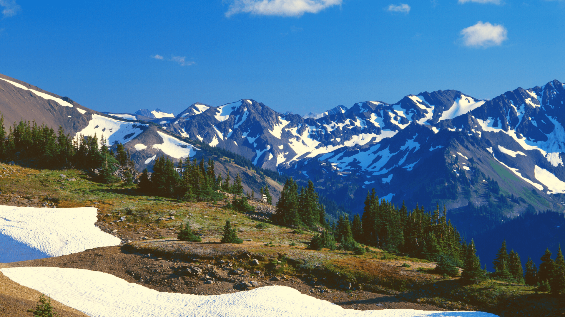
After a short but steep half mile hike from the “Y” in the trail, you will approach a rocky ridge dotted with alpine flowers. Cresting this ridge, you will be met with sweeping views of Mt. Olympus and the Blue Glacier. Mt. Olympus is the tallest point in Olympic National Park, soaring to 7,980 feet above sea level. Its rocky summits are flanked by six named glaciers which see over 220 inches of precipitation each year. Winter storms depositing snow replenish these glaciers each year, however with the effects of global warming, much of this historic snow has now changed to rain. This has resulted in a rapid shrinking of many of these glaciers, including the Blue Glacier. In the past 50 years, temperatures recorded on the Blue Glacier have increased by nearly 7 degrees Fahrenheit, and in the past 30 years the glacier has lost nearly 20 percent of its total ice mass.
The ridge continues to the left and acts as an access point for climbers attempting the summit, but you need not go far to find a perfect lunch spot among the alpine shrubs and flowers. As you gaze out over the sea of ice, be sure to listen for characteristic cracking and popping noises, signifying that the ice is moving imperceptibly slowly. Keep your backpack in arm’s reach while you soak up the views and enjoy your favorite trail snack, Olympic Marmots frequent this area and are always on the lookout for unattended food. These furry critters are endemic to the alpine areas in the park. These house cat-sized mammals are golden brown and live in familial units in rocky outcroppings and talus fields.
After returning to the split in the trail, head toward the terminal Moraine, where you’ll enjoy the short three-tenths of a mile hike uphill until you reach a rocky outcropping with views of a waterfall. Take some time here to inspect the glacial polished rocks caused by thousands of years of slow flowing ice. In this amphitheater of stone, it is easy to realize just how small you are when compared to the colossal forces that formed this area.
Hiking the entirety of the Hoh River Trail provides a comprehensive view of the environmental diversity that Olympic National Park has to offer. From the hundreds of shades of green down in the river valley, to the exposed rock and ice of the higher elevations, this landscape is sure to wow even the most seasoned backpacker.

